
 USA TODAY National
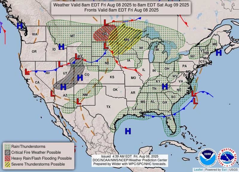
Storms driving damaging winds, large hail and even a couple of tornadoes are threatening the Northern Plains and upper Midwest regions on Aug. 8, forecasters said.
About 5.5 million people live across an area most at risk for strong to severe thunderstorms, including parts of the Dakotas, most of Minnesota and part of Wisconsin, the Storm Prediction Center said. Major cities at risk include Minneapolis, Duluth and St. Paul, Minnesota; Sioux Falls, South Dakota; and Fargo, North Dakota.
The storms are expected to first sweep across parts of North Dakota in the morning before spreading through eastern Minnesota by the evening, and possibly last multiple days, according to the National Weather Service. The end-of-the-week storms come after severe weather was recorded from eastern Montana through North Dakota the night of Aug. 7, with wind gusts above 60 mph, AccuWeather reported.
"Damaging winds may become the primary threat as storms increase and spread eastward through the evening into late tonight," the Storm Prediction Center said in a forecast.
Storms, heavy rain to last into weekend
Thunderstorms on Aug. 8 could cause damage to property in the Dakotas and Minnesota before the threat moves south into a stretch from northern Kansas up through northern Michigan on Aug. 9, forecasters said.
"The storms on Friday may bring monster hail with the potential for some hailstones to reach the size of baseballs or larger," AccuWeather Meteorologist Isaac Longley said.
Along with the severe thunderstorm threat, excessive rainfall will also be a risk on Aug. 8 and into the weekend, forecasters said. Heavy rain and flash flooding are a risk across much of North Dakota, according to a national forecast map issued by the weather service.
Heavy rainfall is expected across northern Minnesota on Aug. 8 before shifting into Iowa, southern Wisconsin and northern Illinois over the weekend, the weather service said.
Central US also battling heat
Extreme heat is also bearing down on much of the central part of the country, with over 40 million Americans under a heat advisory on Aug. 8 in states including Minnesota, Iowa, Nebraska, Missouri, Kansas, Oklahoma, Texas and others. High temperatures are expected to reach triple digits.
There is an end in sight for a heat wave that has also gripped the Desert Southwest with temperatures in the 110s for Arizona and the eastern California deserts. The weather service said temperatures there will drop 5 to 10 degrees over the weekend.
This article originally appeared on USA TODAY: Damaging wind, hail and possible tornadoes threaten central US
Reporting by Jeanine Santucci, USA TODAY / USA TODAY
USA TODAY Network via Reuters Connect

 Local News in Arizona
 The Travel
 ABC News US
 CBS News
 The Baltimore Sun
 CNN Climate
 KSL NewsRadio
 FOX Weather
 The Babylon Bee