
 ClickOrlando
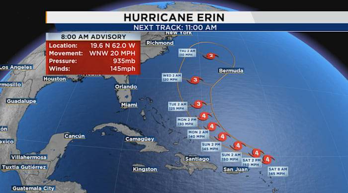
ORLANDO, Fla. – As of the 8 a.m. Saturday advisory, Hurricane Erin is rapidly intensifying, with maximum sustained winds of 145 mph.
The storm is moving west-northwest at 20 mph and its minimum central pressure is 935 MB. 8 AM Advisory
A shift toward the north is anticipated early next week. According to the forecast, Erin’s center is expected to pass just north of the northern Leeward Islands, the Virgin Islands, and Puerto Rico this weekend.
[EXCLUSIVE: Become a News 6 Insider (it’s FREE) | PINIT! Share your photos ]
The outer bands of the storm will bring heavy rainfall to these areas through Sunday, with totals of 2 to 4 inches possible and isolated amounts reaching 6 inches. Flash and urban flooding, as well as landslides or mudslides, may occur in these regions.

 WHAS 11
 The Greenville News
 CBS4 Miami
 Associated Press Top News
 Orlando Sentinel
 WWSB
WWSB KLCC
KLCC WSVN 7 News
 WESH 2 News
 13WMAZ