
 USA TODAY National
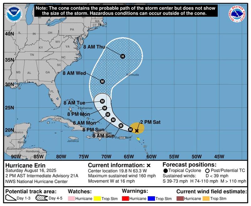
Hurricane Erin strengthened into a fearsome Category 5 hurricane with sustained winds of 160 mph for much of the day on Aug. 16 as it traveled west just north of the Virgin Islands, according to the National Hurricane Center.
The hurricane is not expected to make a direct hit on the United States, but will still drive dangerous surf conditions along the East Coast, said Michael Brennan, hurricane center director. "The weather can be otherwise pretty nice to be at the beach, but the ocean can be very dangerous."
Erin experienced explosive growth early on Aug. 16 and a dramatic increase in wind speeds, but its wind speeds had begun to drop again by early evening. By 11 p.m. ET, the hurricane was in the midst of a replacement of the eyewall, the area of most intense winds around its center, and its maximum sustained winds had dropped to 140 mph, still a "formidable" Category 4 storm, the hurricane center said. Periodic fluctuations in intensity are expected over the next couple of days as the hurricane begins a forecast turn toward the west-northwest and then the north.
"We still expect this to eventually make a more northward turn and stay offshore of the East Coast of the United States. So that certainly is good news when dealing with a storm this powerful," AccuWeather senior meteorologist Dan Pydynowski told USA TODAY.
Hurricane Erin was passing to the north of the northern Leeward Islands on the evening of Aug. 16 and was an estimated 145 miles north-northeast of San Juan, Puerto Rico at 11 p.m. The storm was moving west-northwest at 14 mph. The center's official forecast calls for Erin to move north of the Virgin Islands and Puerto Rico through Sunday, Aug. 17, bringing heavy rainfall of up to 8 inches.
The storm is then forecast to pass east of the Turks and Caicos Islands, where a tropical storm watch is in effect, and the southeastern Bahamas overnight and into Aug. 18. Tropical storm conditions are possible in the Turks and Caicos Islands and the southeast Bahamas as the storm passes, the center said.
Erin becomes season's first Category 5 hurricane
Erin is only the fifth Category 5 hurricane on record to form this early in the hurricane season and the only Category 5 observed outside the Gulf or Caribbean this early in the year, according to WPLG-TV hurricane specialist Michael Lowry.
Under the Saffir-Simpson Hurricane Wind Scale, Category 5 hurricanes are the strongest possible, with sustained winds of at least 157 mph.
The Atlantic hurricane season officially began on June 1 and will last through the end of November. Active hurricane weather typically peaks between mid-August and mid-October. The first hurricane of the Atlantic season, on average, forms on about Aug. 11.
Where is Hurricane Erin? Storm path tracker
As of 8 p.m. ET on Aug. 16, Erin was about 160 miles northwest of Anguilla, among the northern Leeward Islands, and 150 miles northeast of Puerto Rico. It was moving west at about 15 mph with sustained wind speeds of 150 mph.
This forecast track shows the most likely path of the center of the storm. It does not illustrate the full width of the storm or its impacts, and the center of the storm is likely to travel outside the cone up to 33% of the time.
Erin strengthened rapidly and is expected to grow
Erin formed as a hurricane on Aug. 15. It was the first hurricane of the Atlantic season, and quickly became the first major hurricane as well. A major hurricane is one that reaches at least Category 3 status.
"(B)y the middle of next week, Erin is forecast to at least double or triple in size, which will result in rough ocean conditions over the western Atlantic," the hurricane center said.
Erin's hurricane-force winds had a mean diameter of 43 miles on Aug. 16 but are expected to increase to 132 miles in diameter by Aug. 19, while its tropical storm force winds are forecast to reach a mean diameter of 385 miles over the same period.
The storm's outer bands of rain were already beginning to impact the northern Leeward Islands, forecasters said on Aug. 16. Heavy rainfall is expected in the northern Leeward Islands, the Virgin Islands and Puerto Rico for the rest of the weekend, bringing 2 to 4 inches of rain with localized amounts of 6 inches and possible flash flooding.
In its 5 p.m. update, the hurricane center said, "Erin is expected to move just north of the northern Leeward Islands, the Virgin Islands and Puerto Rico through Sunday and pass to the east of the Turks and Caicos Islands and the southeastern Bahamas Sunday night and Monday."
Erin's intensity is expected to fluctuate during the next 24 hours, but it should "remain a strong hurricane during this time," according to hurricane center forecaster Jack Beven.
"Although Erin is a somewhat compact hurricane now, the models are in strong agreement that the system will grow in size over the next several days," Beven said in the hurricane center's 5 p.m. update. "In fact, by the middle of next week, Erin is forecast to at least double or triple in size, which will result in rough ocean conditions over the western Atlantic."
What is an eyewall replacement cycle?
According to an 8 p.m. update from the hurricane center, Erin is possibly undergoing an eyewall replacement cycle.
The National Oceanic and Atmospheric Administration (NOAA) says an eyewall replacement cycle is a natural occurrence for intense hurricanes, such as Erin, in which a new eyewall (ring of thunderstorms) forms outside the existing one, eventually replacing it.
"As a hurricane grows older, it is common for the eyewall to eventually weaken and get replaced by a newer, larger eyewall," according to the NOAA.
When a hurricane has a newer, larger eyewall, it can "bring dangerous weather over a larger region than the older, smaller eyewall would have," the government agency says. During the eyewall replacement cycle, hurricanes often undergo temporary changes in strength (both up and down).
NOAA added that what causes the newer, larger eyewall to form during this process is "not well understood."
Ways communities in Coastal North Carolina can prepare for Hurricane Erin
With Hurricane Erin predicted to move between the Outer Banks and Bermuda, North Carolina Emergency Management has offered guidance for people on the coast to prepare.
In an Aug. 16 Facebook post, the state agency said people in Coastal North Carolina should:
- Know their evacuation zones and routes with NC’s Know Your Zone, which refers to the predetermined evacuation zones in 21 coastal NC counties.
- Protect their homes and loved ones.
- Keep emergency contacts handy.
- Pack their emergency kits.
The NWS Morehead City, North Carolina, said on the afternoon of Saturday, Aug. 16, that a strong long-period swell from Erin will begin to arrive late on the night of Sunday, Aug. 17. Those in the area should expect heightened rip current threats through the upcoming week with swell and seas peaking Wednesday, Aug. 20, into Thursday, Aug. 21.
The Dare County Sheriff's Office, located within the Outer Banks, said in a Facebook post on Saturday, Aug. 16, that people along the coast who "routinely see ocean overwash due to no dune between them and the ocean" should "be ready to protect (their) property and to move away from the oceanfront."
What happens to a hurricane that doesn't make landfall?
If a hurricane does not make landfall, it will eventually dissipate over the ocean, according to the Hurricanes: Science and Society (HSS).
Once a storm moves northward – in the Northern Hemisphere – out of the tropical ocean and into mid-latitudes, "It begins to move over colder water, again losing the warm water source necessary to drive the hurricane," according to the HSS.
"As less moisture is evaporated into the atmosphere to supply cloud formation, the storm weakens," the educational resource says. "Sometimes, even in the tropical oceans, colder water churned up from beneath the sea surface by the hurricane can cause the hurricane to weaken."
According to the center's 5 p.m. update, the slow weakening of Erin is expected to begin on Monday, Aug. 18.
If a hurricane does make landfall, it usually decays quickly because the storm requires evaporation from the warm ocean surface to survive, according to the HSS.
What impacts will Hurricane Erin have on the US?
Erin is expected to make a turn to the north and avoid making landfall altogether. It will pass somewhere between North Carolina's Outer Banks and Bermuda, National Hurricane Center Director Mike Brennan said.
Despite staying well off the coast, Erin will cause dangerous surf conditions up and down practically the entire East Coast, from Florida all the way up to New England beaches, Pydynowski said. The conditions will include high waves and dangerous rip currents. The Outer Banks could see some beach erosion and coastal flooding from high waves, he said.
Erin is expected to bring dangerous conditions to offshore waters and beaches along the Northeast Florida coast from Aug. 18 - 21, including rip currents and rough, high surf with breakers greater than 7 feet on the 19th and 20th, said the weather service office in Jacksonville, Florida.
Weather conditions may seem ideal for a beach trip, but these types of conditions are when rip current fatalities tend to occur, Brennan said. Rip currents may not be visible from shore, so beachgoers should swim near lifeguards and pay attention to posted warnings.
'Catastrophic' Erin underwent unusually rapid intensification
Rapid intensification occurs when a tropical cyclone (whether a tropical storm or hurricane) strengthens by at least 35 mph in a 24-hour period.
In Erin's case, winds strengthened to roughly 80 mph in about a day. Erin was declared a hurricane (winds of at least 74 mph) shortly before 11 a.m. on Aug. 15. A day later, it had strengthened into a Category 5 cyclone (winds of at least 157 mph).
Warm water ahead of Erin as it moved west, a lack of wind shear and its position far enough away from any land to interfere contributed to the strengthening, Pydynowski said.
"These kind of rapid intensification events do occur, but that much that quickly is certainly more toward the uncommon end of things," he said.
Data shows Hurricane Erin's remarkable power
Since 1979, only Hurricane Allen in 1980 had a lower minimum central pressure by August 16, said Phil Klotzbach, a senior research scientist at Colorado State University. Lower pressure in a hurricane means a stronger storm.
Since 1970, only 5 storms in the Atlantic hurricane basin have had 145 mph maximum winds or more by Aug. 16: Allen in 1980, Charley in 2004, Dennis in 2005, Emily in 2005 and Beryl in 2004, Klotzbach noted.
Another disturbance off the East Coast
Another tropical disturbance off the East Coast of the United States had little chance of forming as of Aug. 16, forecasters said.
Disturbance 1 is an area of low pressure off the coast of North Carolina that has about a 10% chance of development into a cyclone, but will likely lose steam by early next week, the hurricane center said. It was producing showers to the east of its center over the Atlantic.
Hurricane Erin spaghetti models
Illustrations include an array of forecast tools and models, and not all are created equal. The hurricane center uses only the top four or five highest-performing models to help make its forecasts.
How do hurricanes form?
Hurricanes are born in the tropics, above warm water. Clusters of thunderstorms can develop over the ocean when water temperatures exceed 80 degrees Fahrenheit. If conditions are right, the clusters swirl into a storm known as a tropical wave or tropical depression.
A tropical depression becomes a named tropical storm once its sustained wind speeds reach 39 miles per hour. When its winds reach 74 mph, the storm officially becomes a hurricane.
Prepare now for hurricanes
Delaying potentially life-saving preparations could mean waiting until it’s too late. "Get your disaster supplies while the shelves are still stocked, and get that insurance checkup early, as flood insurance requires a 30-day waiting period," NOAA recommends.
- Develop an evacuation plan: If you are at risk from hurricanes, you need an evacuation plan. Now is the time to begin planning where you would go and how you would get there.
- Assemble disaster supplies: Whether you’re evacuating or sheltering-in-place, you’re going to need supplies not just to get through the storm but for the potentially lengthy aftermath, NOAA said.
- Get an insurance checkup and document your possessions: Contact your insurance company or agent now and ask for an insurance check-up to make sure you have enough insurance to repair or even replace your home and/or belongings. Remember, home and renters insurance doesn’t cover flooding, so you’ll need a separate policy for it. Flood insurance is available through your company, agent, or the National Flood Insurance Program. Act now, as flood insurance requires a 30-day waiting period.
- Create a family communication plan: NOAA said to take the time now to write down your hurricane plan and share it with your family. Determine family meeting places, and make sure to include an out-of-town location in case of evacuation.
- Strengthen your home: Now is the time to improve your home’s ability to withstand hurricane impacts. Trim trees; install storm shutters, accordion shutters, and/or impact glass; seal outside wall openings.
This article originally appeared on USA TODAY: Hurricane Erin a Category 4 after briefly strengthening to fierce Category 5 storm
Reporting by Jeanine Santucci, Doyle Rice, Dinah Voyles Pulver and Jonathan Limehouse, USA TODAY / USA TODAY
USA TODAY Network via Reuters Connect

 CBS DFW
 WWLP
WWLP FOX 10 Phoenix
 Space War
 VEGAS INC