
 FOX 41 Yakima
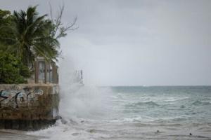
Hurricane Erin restrengthened into a Category 4 storm late Sunday, with forecasters warning it is expected to intensify and grow in size in the coming days as it lashes Caribbean islands with heavy rains that could cause flash floods and landslides.
The first hurricane of what is expected to be a particularly intense Atlantic season, Erin briefly strengthened into a “catastrophic” Category 5 storm before its wind speeds weakened.
Forecasters do not currently expect it to make landfall along its expected course, but tropical storm warnings are in effect for the southeast Bahamas and Turks and Caicos Islands.
Hurricane Erin was located about 130 miles (205 kilometers) east of Grand Turk Island at 11:00 pm Atlantic Standard Time (Monday 0300 GMT), with maximum sustained winds of 130 miles

 Click2Houston
 KFDA-TV Community
 FOX 7 Travis County
 Ledger-Enquirer
 The US Sun Latest
 AlterNet