
 WAND TV
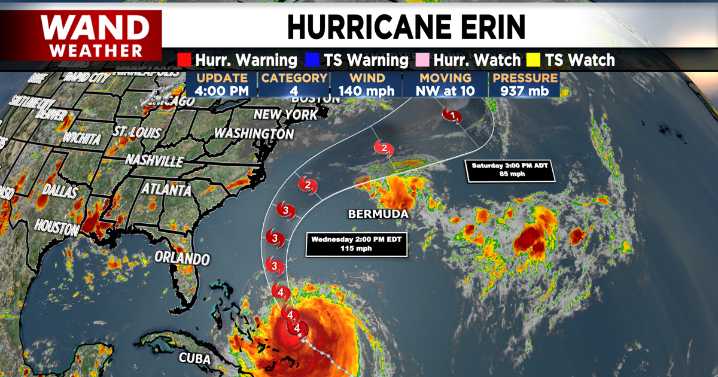
DECATUR, Ill. (WAND) - Behind showers and storms tonight, high pressure gradually moves in with cooler, milder, and calmer conditions. This area of high pressure will have another role, however, in the way Hurricane Erin plays out.
The latest 4pm CT update on Hurricane Erin shows a category 4 hurricane slowly moving northwest at 10 mph. Recent ensemble model runs all show a track that remains a few hundred miles off the southeast and Mid-Atlantic coast. This could still mean impacts such as tropical storm force winds, heavy rainfall, and flash rip currents to areas such as the Outerbanks and Carolina coasts.
High pressure will bring us dry conditions this week, and it will also act as a block along the East Coast. This helps to keep Erin from making landfall. Meanwhile, a ridge that has

 10 Tampa Bay
 CBS Mornings
 The Weather Channel
 FOX 32 Chicago Crime
 Click2Houston
 NBC Chicago
 FOX 32 Chicago
 AlterNet
 New York Post Media
 Washington Examiner
  FOX News Politics