By Joe Lombardi From Daily Voice
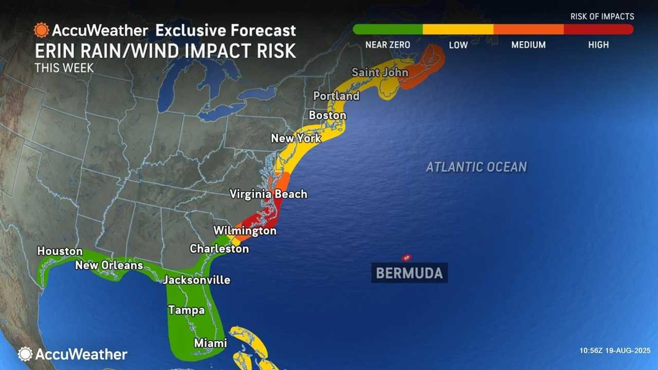
As Hurricane Erin balloons in size and power over the Atlantic, the storm is poised to unleash life-threatening surf, dangerous rip currents, and coastal flooding up and down the US East Coast starting Tuesday, Aug. 19.
Beachgoers and coastal residents from Florida to New England are bracing for a turbulent week as Hurricane Erin, now a major Category 3 storm, churns slowly northward off the Atlantic seaboard.
The National Hurricane Center warns that Erin is expected to grow even larger as it tracks 150 to 250 miles east of North Carolina’s Outer Banks, pushing waves as high as 20 feet toward the shore and threatening widespread beach erosion and flooding.
The most severe impacts are expected to ramp up through Thursday, Aug. 21, when Erin makes its closest approach to the US.
“The dangers at the beach this week should not be underestimated," AccuWeather Lead Hurricane Expert Alex DaSilva. "Dozens of rip current rescues have already been reported along the Carolinas. The force of the rip currents and rough surf along the Atlantic coast this week is life-threatening.
"Hurricane Erin is producing a tremendous amount of energy that will create hazardous beach conditions from Florida to New England.”
Already, lifeguards in North Carolina have reported dozens of rescues as rip currents intensify.
Swimmers and surfers are urged to heed warnings, as dangerous surf and rip currents will only strengthen each day, with hazardous conditions stretching from the Bahamas all the way to Atlantic Canada.
Mandatory evacuations are underway in parts of the Outer Banks, where wind gusts could reach 80 mph and storm surge may wash out Highway 12, potentially cutting off communities.
Coastal flooding during high tide and damaging winds are likely, with a moderate risk to life and property.
Bermuda and the Bahamas are also feeling Erin’s wrath, with tropical storm conditions, torrential rain, and flash flooding expected through Tuesday. The storm has already triggered mudslides and flooding in the northern Caribbean, with rainfall totals topping 8 inches in some areas.
Officials urge everyone along the coast to stay alert, follow local advisories, and avoid the water as Erin’s far-reaching hazards continue to build through the week.
Check back to Daily Voice for updates.

 Daily Voice


 WDAM-TV Crime
 AlterNet
 IMDb TV
 CBS News
 The US Sun Entertainment
 Detroit Free Press