
 USA TODAY National
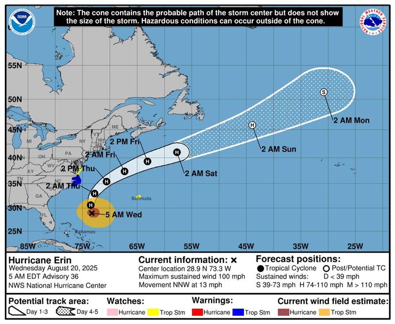
Hurricane Erin's higher tides and big waves are battering much of the East Coast, with the huge storm prompting the expansion of tropical storm and coastal flooding advisories on Wednesday.
Beachfront property owners braced for the worst amid predictions of a storm surge of up to 4 feet and significant coastal erosion. Powerful waves of 15 to 20 feet are expected to slam beaches, especially in North Carolina, for 48 hours or more as the hurricane crawls northward offshore through at least Thursday.
At 11 p.m. ET on Wednesday, the National Hurricane Center reported that tropical storm conditions were at or near portions of the North Carolina coast. By 10:20 p.m. ET, the National Weather Service said about 7.7 million people were under coastal flood warnings and nearly 32 million were under coastal flood advisories along the East Coast.
Earlier, the hurricane center said the outer bands of Erin were brushing the North Carolina Outer Banks and noted that swimming at most East Coast beaches is strongly discouraged "due to life-threatening surf and rip currents."
"Some slight strengthening is possible tonight and Thursday morning, and Erin could become a major hurricane again during that time," the hurricane center said in its 11 p.m. ET advisory. "Weakening is likely to begin Thursday night or Friday, but Erin is forecast to remain a hurricane into the weekend."
The hurricane center reported Erin was carrying sustained winds of 110 mph, the upper end of a Category 2 storm. Winds are forecast to continue increasing to 120 mph, meaning it could become a Category 3 storm later in the day.
The massive hurricane was picking up speed, traveling north near 16 mph, and its center was located about 215 miles southeast of Cape Hatteras, North Carolina. A tropical storm warning is in effect for parts of North Carolina and Virginia as the impacts from Erin spread northward.
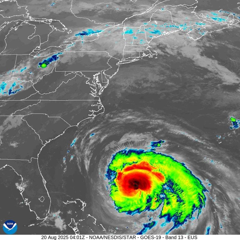
Even though Erin is expected to stay hundreds of miles offshore, its impacts are forecast to worsen as it crawls north and makes its closest approach to the U.S. mainland, likely early Thursday. Erin was generating waves of 35 feet or more at an ocean buoy east-northeast of the Bahamas on Tuesday, creating swells and stirring up a broad swath of the ocean.
Developments:
∎ The National Weather Service warned that Erin's tropical storm-force winds would arrive on the North Carolina coast, especially the Outer Banks, by Wednesday night. Officials said other impacts, like coastal flooding and storm surge, were already being felt. The high tide is also expected to rise much more than usual.
∎ Flood warnings are in place for the Atlantic coast of northeast North Carolina, Virginia, and Maryland, as well as along the Chesapeake Bay south of the York River, the weather service said.
∎ Even as it starts to weaken by Friday, Erin is predicted to retain hurricane strength going deeper into the weekend, the National Hurricane Center said.
North Carolina governor urges residents, visitors to 'remain vigilant'
During a briefing earlier on Wednesday, North Carolina Gov. Josh Stein said the state has prepositioned swift water rescue teams and state National Guard troops, along with boats, high-clearance vehicles, and aircraft. Two helicopters from neighboring states were also on standby to transport food and water, according to the governor.
State officials warned that Erin will cause extensive beach erosion, and coastal flooding may impact roads, structures, and vehicles throughout the week. North Carolina Emergency Management Director Will Ray urged residents to not drive around barricades or through flooded waters.
“While Hurricane Erin is expected to remain offshore, North Carolinians along the coast must remain vigilant as coastal flooding and life-threatening rip currents continue to impact the region,” Stein said in a statement.
State officials noted that ferry service from Ocracoke to Hatteras, part of North Carolina's coastal Outer Banks region, will continue "as long as the weather holds." After a mandatory evacuation order was issued in Hyde County on Sunday, officials said the ferries to and from Ocracoke Island have been used to evacuate 2,263 people and 1,113 vehicles to the mainland.
On Tuesday, Stein declared a state of emergency in preparation for Erin as the hurricane's outer bands moved closer to the coast.
Portion of North Carolina Highway 12 closed due to flooding
In anticipation of Erin, Stein said the North Carolina Department of Transportation used front-end loaders, bulldozers, and other equipment to shore up the dunes to protect Highway 12 in several areas that are vulnerable to flooding and overwash.
By 6:30 p.m. local time, the state Department of Transportation announced that it had closed down a portion of Highway 12, a crucial artery in the Outer Banks, due to flooding. The highway was closed between Oregon Inlet and Hatteras Village.
"Conditions are too unsafe for people to be driving in," the North Carolina Department of Transportation said in a statement. "If you come across any flood waters, turn around, don't drown."
Images shared on social media showed the highway inundated with water as large waves crashed against sand dunes and structures along the coast. The National Weather Service office in Newport and Morehead, North Carolina, said the highway was completely submerged north of Hatteras Village by around 8 p.m. local time.
Widespread coastal flood advisories in New York City
Coastal flooding from Hurricane Erin is expected across much of New York City’s waterfront, possibly impacting homes, streets, and businesses from Aug. 21 to Aug. 22, city officials warned.
Advisories were in place across the five boroughs, with flooding of as much as 2 1/2 feet Thursday evening in parts of southern Queens with high tide, the city Emergency Management said on X. In Queens, officials expect widespread flooding of low-lying properties, roads, and basements near waterfronts. Flooding would continue with Friday’s high tides.
Manhattan, Brooklyn, the Bronx, and Staten Island are projected to see 1 to 2 feet of flooding beginning Thursday evening and into Friday, city alerts warned.
Officials advised people near coastal areas to move cars to higher ground before high tide, and to protect basements, which are often converted into apartments that can be threatened by flooding.
− Eduardo Cuevas, USA TODAY
NASA wants your before-and-after Hurricane Erin photos
This summer and fall, NASA is inviting the public to participate in a new citizen science effort, which the agency is calling NASA Response Mappers.
NASA is introducing the project amid Hurricane Erin, asking people to submit their hurricane-related photos to help improve emergency disaster response. Those who live in the Southeast U.S. are invited to submit photos taken before and after hurricanes hit their area.
"Your contributions could ultimately help emergency managers make faster and better-informed decisions when it matters most and strengthen your community’s ability to respond and recover from disasters," NASA said on a webpage explaining the project.
Each submitted photo will be geotagged and time-stamped, providing scientists and disaster response professionals with real-time information about storm damage in specific areas.
The photos will become part of an open dataset intended to validate or even improve upon assessments from satellite imagery.
What's after Erin?
In addition to Erin, forecasters are watching two other areas of disturbed weather far out in the Atlantic Ocean on Aug. 20. Fortunately, neither currently appears to be a threat to any land areas.
But both have a medium chance of becoming tropical depressions later this week or over the weekend, the hurricane center said. The next named storm of the Atlantic hurricane season will be Fernand.
Hurricane Erin impacts land from hundreds of miles away
Along North Carolina's Outer Banks, which is under a state emergency order, tides and waves began building on Aug. 19, even with Erin still more than 500 miles away. As an afternoon high tide approached in Buxton, ocean waves already were rushing under some beachfront structures on pilings and washing over portions of Highway 12, the main transportation artery for the islands.
"We've seen some very impressive, and dangerous, waves on webcams up and down the coast," Roger Martin, a meteorologist with the National Weather Service in Morehead City, North Carolina, said in an evening update. "Significant, and large, breaking waves … will only strengthen over the next 24-48 hours."
The hurricane's outer bands are expected to bring worsening weather conditions to North Carolina's coast by the evening of Aug. 20, the hurricane center said.
Erin's deadly rip currents forecast
From South Florida to Long Island, officials warn of life-threatening rip currents, urging those who visit the beach to stay out of the water. But in North Carolina on Aug. 19, surfers flocked to the coast.
"The waves that Erin is going to kick up as it moves across the western Atlantic are going to create some very dangerous ocean conditions," said hurricane center Director Michael Brennan. In addition to flying red warning flags, many beaches have been closed to swimmers.
Erin is predicted to turn to the north and then east-northeast along a path that takes it out into the open Atlantic in the coming days.
Outer Banks brace for big waves and high water from Erin
State officials said it’s likely that Highway 12 along the Outer Banks of North Carolina could be impassable for several days after the storm, given the duration of Erin's high tides and pounding waves.
"We cannot put this more bluntly: We now EXPECT there will be times over the next week that NC12 becomes impassable due to significant ocean over wash," said the North Carolina Department of Transportation. In a worst-case scenario, the highway could be closed for several days, officials said this week.Evacuations were underway for visitors and others who wouldn't feel safe with the only highway closed for several days, including mandatory orders on Ocracoke and Hatteras islands. Dare County made buses available to those who needed transportation to evacuate and advised them to bring clothing and medicines for seven days.
The transportation department pushed up sand piles to try to safeguard the highway from water washing over or through the dunes. Major flooding is forecast at Duck, North Carolina, but several inches below the record of 7.8 feet, the weather service said.
The weather service sees an increasing likelihood that some areas more inland and on the mainland, including Dare County, could experience some tropical storm-force winds.
Nearly 75 rip current rescues were reported this week in Wrightsville Beach, North Carolina, south of the Outer Banks.
Where are there tropical storm warnings, watches because of Erin?
The National Hurricane Center issued tropical storm and storm surge watches and warnings on Aug. 20. According to the center, a tropical storm warning is in place where tropical storm conditions, including winds of 39 to 73 mph, are expected soon, in this case within the next 24 hours.
A tropical storm watch means conditions are possible within 48 hours. A storm surge warning means there is a danger of life-threatening inundation from rising water moving inland within the next 36 hours.
These are the warnings and watches in place along the East Coast:
- Tropical storm warning: Beaufort Inlet in North Carolina's Outer Banks to Chincoteague, Virginia, including the Pamlico and Albemarle sounds
- Storm surge warning: Cape Lookout, North Carolina, to Duck, North Carolina
State-by-state Erin forecast details
The weather service and state officials have provided the following information:
New York: Widespread dune erosion and beach flooding are likely with successive high tides through Friday morning, with waves of up to 15 feet or more and higher-than-normal tides. Gusts up to 40 mph are possible, with the highest winds expected along eastern Long Island.
State officials advised residents to prepare for the possibility of dangerous conditions along beaches and coastal communities. New York Mayor Eric Adams directed the closing of all beaches for swimming on Aug. 20 and Aug. 21.
New Jersey/Delaware: Tropical storm-force gusts are possible along the coast on Thursday, breaking waves of 5 to 8 feet on Wednesday and 7 to 11 feet on Thursday.
Maryland: Higher tides could lead to coastal flooding, and winds are expected to increase over Chesapeake Bay overnight Wednesday. Coastal flood advisories were issued, including a flood warning for Annapolis, where flooding is expected in the low-lying historic community.
Virginia: Minor or isolated coastal flooding is expected through the weekend.
South Carolina and Georgia: “Significant” ocean swells are expected, with breaking waves of 6 feet or higher through Wednesday night, with the period of greatest concern expected during Wednesday night's high tide. Coastal flooding is also possible, but major flooding is not forecast.
Florida: As with all other states to its north, Florida is expecting a high risk of life-threatening rip currents north of Palm Beach County. In South Florida, largely spared the brunt of Erin’s ocean activity, the weather service warned conditions could get rougher once the storm passes and starts to blow ocean waves in from the north.
Hurricane Erin tracker
This forecast track shows the most likely path of the center of the storm. It does not illustrate the full width of the storm or its impacts, and the center of the storm is likely to travel outside the cone up to 33% of the time.
This article originally appeared on USA TODAY: Hurricane Erin ready to unleash its power on North Carolina's Outer Banks: Live updates
Reporting by Dinah Voyles Pulver, Jeanine Santucci, Doyle Rice and Jorge L. Ortiz, USA TODAY / USA TODAY
USA TODAY Network via Reuters Connect

 America News
 CBS News Video
 WCNC Charlotte Weather
 The Atlanta Journal-Constitution Crime
 CBS News
 The Daily Beast