
HASTINGS, Neb. (KSNB) - It was another hot day today but showers and thunderstorms return late tonight into tomorrow which will cool us down for Sunday. Isolated thunderstorms are expected to develop across western Nebraska this evening as a low pressure system moves through to the northwest. A few storms could have small hail and gusty winds, but the overall severe threat is low. Showers and storms will continue to move east into tomorrow morning before dissipating across eastern Nebraska. Temperatures tonight fall into the upper 50’s to low 60’s to the west, with mid to upper 60’s to the east. Mostly cloudy skies are expected tomorrow along and west of highway 281. This will keep temperatures cooler in the upper 60’s to mid 70’s. Areas to the east could see temperatures back into the low
Showers and thunderstorms tonight through tomorrow, some could be strong; More chances by midweek
 KSNB Local4 Central Nebraska6 hrs ago
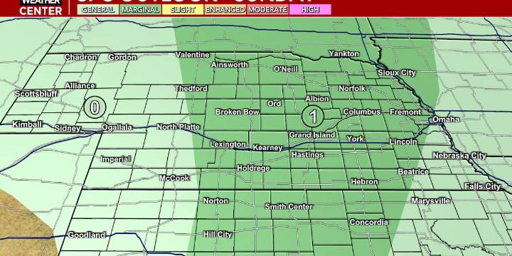
1494

 6abc Action News Sports
 Wilmington Star-News Sports
 Raw Story
 AlterNet
 5 On Your Side Sports
 Women's Wear Daily Retail
 ScienceAlert en Español
 @MSNBC Video
 FOX News Videos