
 USA TODAY National
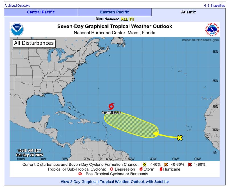
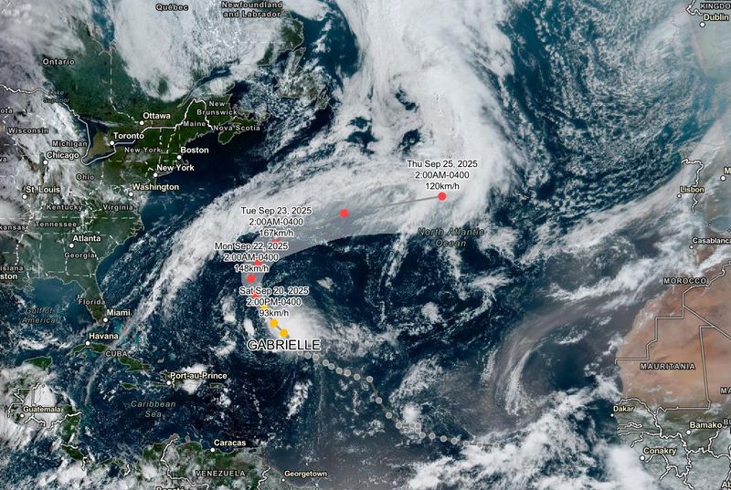
Tropical Storm Gabrielle continues to strengthen as it moves across the Atlantic Ocean with forecasters expecting the storm to become a hurricane by Sunday.
The storm, given the name Gabrielle on Sept. 17, is moving northwestward at about 13 mph and is expected to have reached hurricane strength when it passes east of Bermuda beginning Sunday night, the National Hurricane Center said in an update at 11 a.m. Saturday, Sept. 20.
Gabrielle was positioned Saturday about 615 miles southeast of Bermuda and 540 miles northeast of the Northern Leeward Islands, which includes Anguilla, Montserrat and Saint Martin, the NHC said. Currently, the storm is producing maximum sustained winds of 60 mph with higher gusts, but is expected gradually strengthen.
Bermuda is beginning to be hit by swells generated by Gabrielle and those are expected to build over the weekend and will likely result in life-threatening surf and rip current conditions, the hurricane center said.
Swells are expected to hit beaches along the Atlantic coast, from North Carolina and north as far as the coast of Atlantic Canada; the swells could cause life-threatening surf and rip current conditions, beginning late this weekend into early next week, the NHC said.
The NHC warned those on Bermuda to expect wind and rainfall from Gabrielle.
Gabrielle became the 7th named storm to form in the Atlantic basin this year – and the first named storm in the Atlantic since Aug. 28, an "unprecedented dry spell" during the usually busy hurricane season, WPLG-TV hurricane specialist Michael Lowry told USA TODAY at the time.
Tropical Storm Gabrielle tracker
Tropical Storm Gabrielle spaghetti models
Illustrations include an array of forecast tools and models, and not all are created equal. The hurricane center uses only the top four or five highest-performing models to help make its forecasts.
The hurricane center also is tracking an eastern Atlantic tropical wave off the western coast of Africa that forecasters say could slowly develop. But forecasters put its likelihood of formation at low through the next seven days.
The hurricane center is also monitoring two systems in the Eastern Pacific with disparate chances of developing into tropical depressions over the next few days.
Located a couple of hundred miles south of Mexico's southern coast is a "broad area of low pressure," which is producing a large area of disorganized showers and thunderstorms" and will likely to develop into a tropical depression, the NHC said.
The system, which is moving west-northwestward at 5 to 10 mph parallel to the country's coast, has a medium chance of developing over the next 48 hours and a high chance during the next 7 days, the center said.
Another system, labeled for tracking purposes as Invest 96L, located west of the Revillagigedo Islands (south of Cabo San Lucas), has weakened during the past 12 hours and the disturbance is now expected to have a low chance of development in the next 48 hours, the center said.
How do hurricanes form?
Hurricanes are born in the tropics, above warm water. Clusters of thunderstorms can develop over the ocean when water temperatures exceed 80 degrees. If conditions are right, the clusters swirl into a storm known as a tropical wave or tropical depression.
A tropical depression becomes a named tropical storm once its sustained wind speeds reach 39 mph. When its winds reach 74 mph, the storm officially becomes a hurricane.
Prepare now for hurricanes
Delaying potentially lifesaving preparations could mean waiting until it’s too late. "Get your disaster supplies while the shelves are still stocked, and get that insurance checkup early, as flood insurance requires a 30-day waiting period," the National Oceanic and Atmospheric Administration recommends.
- Develop an evacuation plan. If you are at risk from hurricanes, you need an evacuation plan. Now is the time to begin planning where you would go and how you would get there.
- Assemble disaster supplies. Whether you’re evacuating or sheltering in place, you’re going to need supplies not just to get through the storm but for a possibly lengthy aftermath, NOAA said.
- Get an insurance checkup and document your possessions. Contact your insurance company or agent now and ask for an insurance checkup to make sure you have enough insurance to repair or even replace your home and belongings. Remember, home and renters insurance don’t cover flooding, so you’ll need a separate policy for those. Flood insurance is available through your company, agent or the National Flood Insurance Program.
- Create a family communication plan. NOAA says you should take the time now to write down a hurricane plan and share it with your family. Determine family meeting places and make sure to include an out-of-town location in case of evacuation.
- Strengthen your home. Now is the time to improve your home’s ability to withstand hurricanes. Trim trees and install storm shutters, accordion shutters and impact glass, and seal outside wall openings.
Contributing: Gabe Hauari and Doyle Rice.
Mike Snider is a national trending news reporter for USA TODAY. You can follow him on Threads, Bluesky, X and email him at mikegsnider & @mikegsnider.bsky.social & @mikesnider & msnider@usatoday.com
What's everyone talking about? Sign up for our trending newsletter to get the latest news of the day
This article originally appeared on USA TODAY: Tropical Storm Gabrielle remains on path to become hurricane by Sunday. See tracker.
Reporting by Mike Snider, USA TODAY / USA TODAY
USA TODAY Network via Reuters Connect

 Newsweek Top
 10 Tampa Bay
 FOX 13 Tampa Bay Crime
 People Human Interest
 Florida Today
 FOX Weather
 CBS News
 WCNC Charlotte Weather
 KY3
KY3 Task and Purpose
 America News
 Los Angeles Times World