
 USA TODAY National
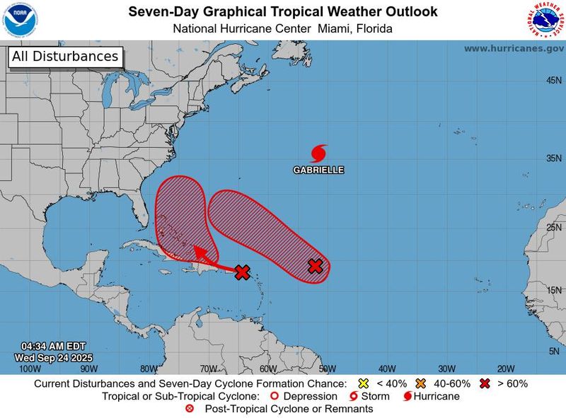
A pair of tropical waves developing in the Atlantic on the heels of Hurricane Gabrielle have forecasters perplexed about the near future of hurricane season as the systems could soon become the next two named storms of the 2025 Atlantic hurricane season.
"Invest 93L" and "Invest94L," as they're dubbed for now, are highly likely to become tropical cyclones in the next week, the National Hurricane Center said, but their exact paths and potential to impact the United States remain unpredictable for now. One of the waves is expected to bring heavy rain to Puerto Rico and the Virgin Islands starting Sept. 24, forecasters said.
Should they both form into tropical storms, reaching wind speeds of at least 39 mph, they would be given the next two names in the lineup for the 2025 Atlantic hurricane season: Humberto and Imelda.
What will the next tropical storms be named?
Tropical storms get names when their wind speeds reach 39 mph; if speeds reach 74 mph, they become hurricanes. The list of names for each hurricane season is established well in advance by the World Meteorological Organization. Names have been released through the 2030 season. Each tropical storm receives the next name on the list in alphabetical order.
There have been seven named storms in the Atlantic so far this season, with the most recent being Hurricane Gabrielle, currently a Category 3 storm approaching the Azores.
These are the next five names on the Atlantic list:
- Humberto
- Imelda
- Jerry
- Karen
- Lorenzo
How to pronounce Humberto, Imelda
Humberto is pronounced "oom-BAIR-toh," according to the hurricane center.
Imelda is pronounced "ee-MEHL-dah."
Will the storms impact the US?
Hurricane experts say both disturbances are worth keeping an eye on for potential impacts to the United States, whether or not they ever reach land. It's still too soon to predict their exact tracks.
"Folks on the East Coast from Florida through New England should monitor the progress of these systems in the next few days to see if we can pull a signal out of this. Because right now, we can't," said Houston-based meteorologist Matt Lanza in his Substack "The Eyewall" on Sept. 23.
Invest93L has a 90% chance of cyclone formation within seven days, and is likely to become a tropical depression in the next couple days, the hurricane center said on Sept. 24. Invest 94L has an 80% chance in the same time frame, with conditions more favorable for development late in the week or the weekend.
Contributing: Doyle Rice, USA TODAY
This article originally appeared on USA TODAY: Hurricane forecasts could soon be abuzz with these 2 storm names
Reporting by Jeanine Santucci, USA TODAY / USA TODAY
USA TODAY Network via Reuters Connect

 Gainesville Sun
 Florida Today
 KICKS 105
 The radio station 99.5 The Apple
 WLOX
WLOX KSNB Local4 Central Nebraska
 WVLT
WVLT AccuWeather Severe Weather
 FOX 5 Atlanta Crime
 US Magazine Entertainment