
 USA TODAY National
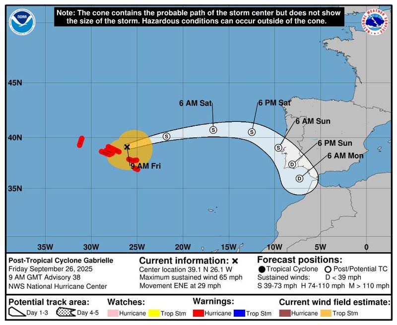
Hurricane Humberto, now a Category 1 storm, could become a major hurricane on Friday, Sept. 26, or Saturday, Sept. 27, according to the National Hurricane Center.
According to an 11 a.m. ET advisory on Friday, Sept. 26, by the National Hurricane Center in Miami, the storm is spinning around 450 miles northeast of the northern Leeward Islands in the Caribbean, with maximum sustained winds of 90 mph.
The storm is moving northwest at 5 mph and is expected to intensify into a major hurricane, according to the National Hurricane Center. A storm becomes a major hurricane when its wind speeds exceed 110 mph and is considered to be a Category 3 hurricane or higher.
As of Friday morning, there are no coastal watches or warnings in effect related to Hurricane Humberto.
Hurricane Humberto tracker
This forecast track shows the most likely path of the center of the storm. It does not illustrate the full width of the storm or its impacts, and the center of the storm is likely to travel outside the cone up to 33% of the time.
Hurricane Humberto spaghetti models
Illustrations include an array of forecast tools and models, and not all are created equal. The hurricane center uses only the top four or five highest-performing models to help make its forecasts.
Gabrielle becomes a post-tropical cyclone
According to the National Hurricane Center, the center of Gabrielle is moving away from the Azores, an autonomous region of Portugal in the mid-Atlantic. It has dissipated into a post-tropical cyclone with maximum sustained winds of 65 mph.
Winds will continue to weaken later in the afternoon, while flooding across the high terrain in the Central Azores is also expected to subside.
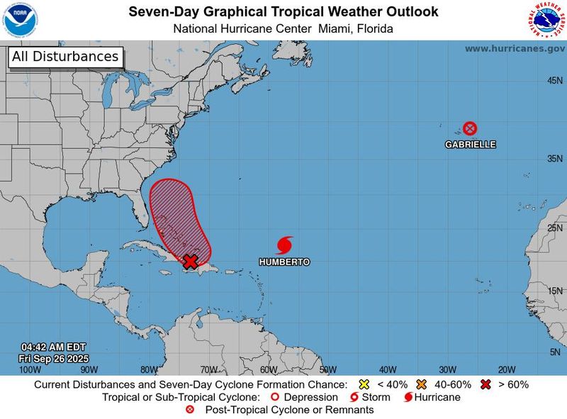
NHC tracking one more system in the Atlantic
Humberto is not the only storm in the Atlantic Ocean, according to the NHC.
Invest 94L, a tropical wave moving in the Caribbean Sea, is likely to become the next named storm, Tropical Storm Imelda, by the weekend as it moves into the Bahamas, and it's increasing the likelihood of potential impacts along the U.S. coast, according to the National Hurricane Center.
The storm has already brought "heavy rains and gusty winds" to the Dominican Republic, Haiti and the Turks and Caicos Islands. The storm is expected to reach the Bahamas and eastern Cuba within the next couple of days.
Invest 94L has a 90% chance of formation in the next 48 hours and a 90% chance of formation in the next 7 days, according to the NHC.
Where will the storm go? Path uncertain.
Uncertainty remains in the track forecast for the wave, with the models meteorologists use to forecast the storm's track divided about its eventual direction. The models show chances of the wave moving very near the coast or possibly making landfall in the Carolinas, as well as chances of it veering out over the open Atlantic as other storms have done this season.
"Interests in the Dominican Republic, Haiti, the Turks and Caicos Islands, and the Bahamas should monitor the progress of this system. Regardless of development, heavy rains and gusty winds are likely across that region during the next couple of days," the hurricane center said. "While there is significant uncertainty in the long-range track and intensity of the system, the chances of wind, rainfall, and storm surge impacts for a portion of the Southeast U.S. coast are increasing. Interests in that area should monitor the progress of the system."
How do hurricanes form?
Hurricanes are born in the tropics, above warm water. Clusters of thunderstorms can develop over the ocean when water temperatures exceed 80 degrees. If conditions are right, the clusters swirl into a storm known as a tropical wave or tropical depression.
A tropical depression becomes a named tropical storm once its sustained wind speeds reach 39 mph. When its winds reach 74 mph, the storm officially becomes a hurricane.
Prepare now for hurricanes
Delaying potentially lifesaving preparations could mean waiting until it’s too late. "Get your disaster supplies while the shelves are still stocked, and get that insurance checkup early, as flood insurance requires a 30-day waiting period," the National Oceanic and Atmospheric Administration recommends.
- Develop an evacuation plan. If you are at risk from hurricanes, you need an evacuation plan. Now is the time to begin planning where you would go and how you would get there.
- Assemble disaster supplies. Whether you’re evacuating or sheltering in place, you’re going to need supplies not just to get through the storm but for a possibly lengthy aftermath, NOAA said.
- Get an insurance checkup and document your possessions. Contact your insurance company or agent now and ask for an insurance checkup to make sure you have enough insurance to repair or even replace your home and belongings. Remember, home and renters insurance don’t cover flooding, so you’ll need a separate policy for those. Flood insurance is available through your company, agent or the National Flood Insurance Program.
- Create a family communication plan. NOAA says you should take the time now to write down a hurricane plan and share it with your family. Determine family meeting places and make sure to include an out-of-town location in case of evacuation.
- Strengthen your home. Now is the time to improve your home’s ability to withstand hurricanes. Trim trees and install storm shutters, accordion shutters, and impact glass, and seal outside wall openings.
This story has been updated with new information.
Contributing: Gabe Hauari, USA TODAY
Julia is a Trending reporter for USA TODAY and covers all things Labubu and Pop Mart, scientific studies and trending news. Connect with her on LinkedIn, X, Instagram, and TikTok: @juliamariegz, or email her at jgomez@gannett.com
This article originally appeared on USA TODAY: Tracking Hurricane Humberto: See path tracker, spaghetti models
Reporting by Julia Gomez, Doyle Rice and Dinah Voyles Pulver, USA TODAY / USA TODAY
USA TODAY Network via Reuters Connect

 11Alive
 The Hill
 Law & Crime
 FOX 51 Gainesville Crime
 WSVN 7 News
 Breitbart News
 People Human Interest
 Ocala Star-Banner
 First Coast Crime
 KPTV Fox 12 Oregon