
 USA TODAY National
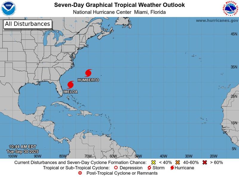
Though the center of both storms are well offshore, a pair of hurricanes will still bring dangerous conditions to beaches along the East Coast into early October, forecasters said as they credited a rare scientific phenomenon with helping steer the worst of the danger out to sea.
"Swells generated by Hurricane Imelda and Hurricane Humberto are affecting the Bahamas and are currently spreading to much of the U.S. east coast," the National Hurricane Center warned on the morning of Sept. 30. "These swells are likely to cause life-threatening surf and rip current conditions."
Rip currents are a deadly hazard at beaches across the nation, with as many as 100 fatalities reported per year, according to the United States Lifesaving Association.
In addition, rain from the outer bands of Imelda could lead to flash flooding in portions of the Carolinas. Some storm surge flooding is also possible in Florida due to Imelda, the hurricane center said.
Bermuda is also in the line of fire from the storms.
Why didn't Imelda hit the US? Is it the Fujiwhara Effect?
High pressure building over the Northeast is blocking Hurricane Imelda's northward path this week, AccuWeather senior meteorologist Alex Sosnowski said in an online forecast. "Instead of the storm tracking inland over the southeastern states as originally feared, Major Hurricane Humberto, tracking west of Bermuda, will give Imelda a tug and help steer it away from the U.S. at midweek."
"This is a case where the rare Fujiwhara Effect will help steer Imelda away from the U.S.," AccuWeather lead hurricane expert Alex DaSilva said.
The Fujiwhara Effect is the interaction of two tropical systems that causes both to dance around each other like a spinning teacup amusement park ride or ballroom dancers moving in unison.
"For a time, Humberto and Imelda may only be about 500 miles apart, but close enough for some interaction between the two," DaSilva said.
Where are Hurricanes Imelda and Humberto?
Both hurricanes are in the Atlantic Ocean and are moving away from the United States. As of 11 a.m. Sept. 30, the center of Humberto was located 300 miles west of Bermuda. It had maximum sustained winds of 80 mph and was moving to the north-northwest at 18 mph.
As of 8 a.m. ET Sept. 30, the center of Imelda was located about 755 miles west-southwest of Bermuda. It had maxiumum sustained winds of 75 mph and was moving northeast at 7 mph.
Will Bermuda take a hit from either storm?
While Humberto is forecast to give a glancing blow to Bermuda, it's Imelda that might track directly over the tiny island nation.
First, on Sept. 30, Bermuda will be impacted by squally rain, gusty winds and rough seas due to Humberto's large size, even though the hurricane will pass more than 100 miles to the west and north.
Then barely a day later, Imelda will come cruising in from the west Wednesday with wind-swept rain, flooding and pounding seas, AccuWeather said.
A hurricane warning was issued for Bermuda on Sept. 30.
The swarm of tropical activity will affect small craft, cruise and shipping interests around the islands for multiple days, AccuWeather said.
What's next?
"We should have a breather after Imelda dissipates later this week," said Houston-based meteorologist Matt Lanza in his Substack The Eyewall on Sept. 30.
"We’ll then turn our attention to whatever comes next, which may or may not be in the Caribbean. Model 'noise' is inching up a bit late, but there remains no real signal. Good news for now," Lanza said.
This article originally appeared on USA TODAY: 2 hurricanes off East Coast churn up danger amid 'rare Fujiwhara Effect'
Reporting by Doyle Rice, USA TODAY / USA TODAY
USA TODAY Network via Reuters Connect

 Associated Press Top News
 America News
 FOX 13 Tampa Bay Crime
 WAND TV
 WBAL NewsRadio
 Cache Valley Daily
 People Human Interest
 Gainesville Sun
 Raw Story
 5 On Your Side Sports