
 USA TODAY National
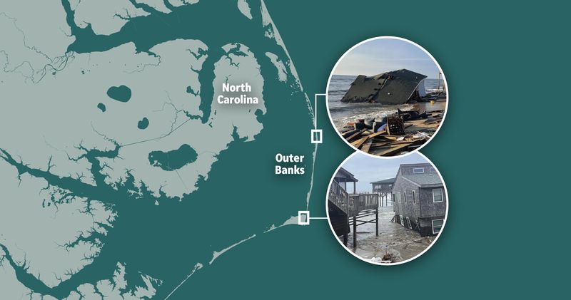
Eight unoccupied houses were claimed by roaring Atlantic surf this week on the Outer Banks — a 200-mile ribbon of barrier islands on the North Carolina coast — as Hurricane Humberto and Hurricane Imelda passed offshore.
Since May 2020, at least 20 homes have been lost.
Home to tens of thousands of permanent residents and visited by more than 2 million people each year, the region's remote beaches, dunes and inlets comprise the "most dynamic natural landscapes occupied by man," according to U.S. Geological Survey scientists.
Here's a closer look at what was lost, and the ongoing erosion of these prized beaches:
Can't see the map above? Please click here to reload the page.
The recent collapses were a result of hurricanes Humberto and Imelda, which made a mess of the Atlantic Ocean in the coastal waters off the Outer Banks.
Five of the houses fell between 2 p.m. and 2:45 p.m. on Sept. 30, along Cape Hatteras National Seashore as a high tide pounded the beach and washed over dunes, the park service said. Another collapsed that evening at 11 p.m., when the weather service estimated surf height at 8 to 12 feet. The seventh house collapsed on Oct. 1, around 8 p.m., the seashore announced. The 8th house slid into the ocean nearly 24 hours later.
A number of factors contribute to the erosion of the Outer Banks barrier islands, including their low-lying and naturally sandy character, which leaves them vulnerable to shifting and wave action. The intensified storms and rising sea levels brought on by climate change greatly speed up this natural process, according to NOAA.
Contributing: Dinah Voyles Pulver, USA TODAY
This article originally appeared on USA TODAY: See Outer Banks houses collapse, washed into surf by a pair of hurricanes
Reporting by Janet Loehrke, USA TODAY / USA TODAY
USA TODAY Network via Reuters Connect

 KOLD Tucson
 NBC News
 The Weather Channel
 WIS News 10
 AccuWeather Severe Weather
 CNA Entertainment
 Raw Story
 Associated Press Top News
 The Columbian Sports