
Monday will bring increasing cloud cover with skies ranging between partly to mostly cloudy, watch for isolated showers. We'll still see above normal highs in the low 80s, but a big change is on the way! Showers develop overnight with showers and t-showers likely Tuesday as a cold front slides southeast late in the day. While severe storms aren't expected, watch for gusty wind and heavy rain. Expect widespread, beneficial rainfall around 1" to 3". In the wake of that front, much cooler air filters in with Tuesday's high near normal, in the low to mid 70s. We'll bottom out in the upper 60s Thursday with chilly lows in the 40s. High pressure takes over and sunshine with gradually warming highs will take over the rest of the week.
Rain on the Rise Monday Night, Tuesday
 LEX 18 News15 hrs ago
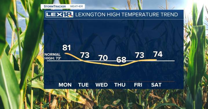
109

 WRCB-TV
 News Channel 36
 FOX 13 Tampa Bay Crime
 The Washington Post
 WISC-TV Channel 3000
 Spectrum News Louisville
 WCBI-TV
 Hawaii News Now
 Florida Today
 WFMJ-TV Sports