
 FOX 8 News
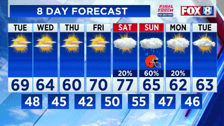
(WJW) -- A few clouds this morning with sunshine and temperatures in the upper 60s and 70s.
Highs on Wednesday and Thursday will only be in the upper 50s and lower 60s. There could be a threat of frost Wednesday night as temperatures dip into the 30s in some places.
Temperatures will go back above normal Saturday (mid/upper 70s) before a cool down early next week.
We are tracking a fairly aggressive front this weekend that could bring widespread rain coverage on Sunday.
Here’s the latest 8 Day Forecast:
The long-range outlook indicates a period of cooler air becoming stronger and more frequent, with milder breaks in between, over the next two weeks.
Stay up-to-date by downloading the FOX 8 apps, including the new FOX 8 CLE+ streaming app available for free on Amazon Fire, Roku, and A

 WTVM News Leader 9
 WMTV NBC15
 WDHN News
 America News
 Associated Press US News
 Associated Press US and World News Video
 People Human Interest
 Eyewitness News 3
 Gainesville Sun
 CBS Boston
 NBC News
 FOX News Videos