
Clear skies will set the stage for a chilly night tonight with lows dipping well into the 30s. However, looking ahead to the work week, we will see our temperatures rebound nicely. With persistent southerly winds, we're forecasting warmer conditions to take hold. We should climb to near the 60s by Monday and then push near the 70s midweek. There's a chance for some of that moisture to return by late Thursday night into Friday, bringing with it scattered showers and thunderstorms. Another storm system could bring showers again Saturday afternoon and night, potentially ahead of a more substantial cold front. Widespread cooler air might finally arrive by next Sunday. We'll be monitoring all these changes for you!
Dry & Quiet to Start the Week
 WSIL-TV10 hrs ago
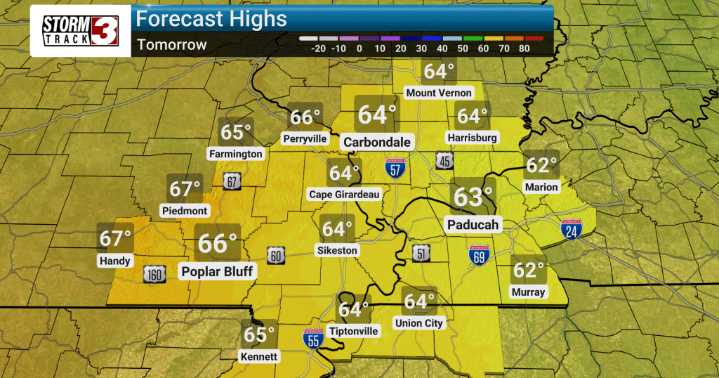
63

 WAAY TV
 WAFB
WAFB WITN-TV
 Northern News Now
 WHAS 11
 KNOE
KNOE KTVU San Francisco
 KSNB Local4 Central Nebraska
 Battle Creek Enquirer
 The Bay City Times
 Courier Journal
 WILX News 10
 Newsweek Top