
 The Conversation
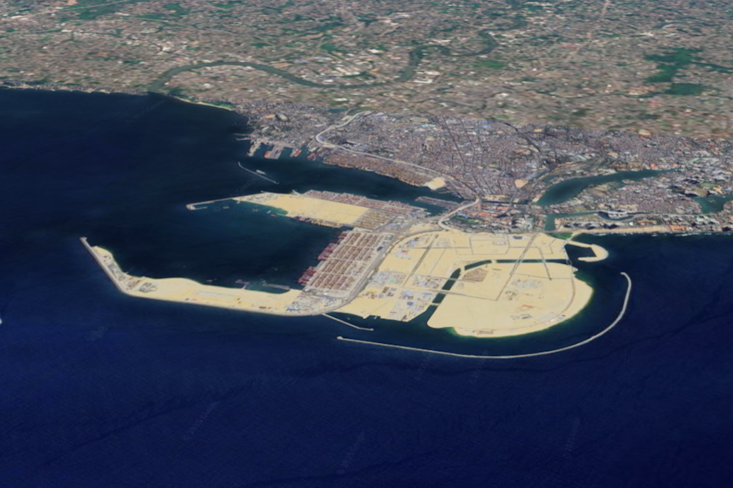
The coastlines I trace resemble logos and luxury icons: palms, crescents, pixelated grids, surreal ornaments etched into shallow seas. The cartography is striking. The environmental consequences are very concerning.
There is an urgent need to evaluate the negative effects and risks associated with these artificial structures around the world, especially as climate change makes sea-level rise more extreme.
For ten years, I have been tracking changing coastlines and trying to map the spread of artificial coastal developments. But this is difficult for two reasons.
First, it’s tricky to define what counts as reclamation and what doesn’t. Does a polder (a piece of low-lying land reclaimed from the sea) belong in the same category as a luxury island? Do sea walls belong in the same category as “dredge-and-fill peninsulas” (land created by digging sand from a seabed or river banks that is used to fill an area of water).
Second, at a global scale, constantly updating maps with rapidly changing unnatural boundary designs is a never-ending task, which involves extracting data from satellite images.
The geometry of reclaimed sites and artificial shorelines can seem bizarre – ranging from the leafed fronds of Ocean Flower Island in Hainan, China, to perfect crescents in Durrat Al Bahrain in the Persian Gulf, and straight-edged lattices in Lagos, Nigeria. In most cases, they are designed to look appealing without much consideration of ocean health or storm resilience.

Sharp angles interrupt longshore drift. Features such as headlands, jetties or bends in the coastline block or redirect the flow of sand moved by waves. This causes sand to build up in some areas while leaving other beaches with less sand, leading to erosion.
With artificial coastlines, these effects are amplified – a particular problem in places without the financial means to manage their beaches.
Grid-like canals slice tidal flats into disjointed basins. On maps, the lines are neat – but in reality, they produce messy hydrodynamics and fragmented ecosystems.
Such misplaced “neatness” can have far-reaching consequences. Reclamation destroys mangroves, muddy tidal flats and seagrass meadows – ecosystems which act both as valuable stores of atmospheric carbon and fish nurseries.
Dredging also stirs up sediment which clouds the water downstream, making it harder for coral reefs to survive. This compounds climate stress, acting as a threat multiplier. Most of the artificial coastlines aren’t as resilient to extreme weather as they could be.
Read more: New islands are being built at sea – but they won't help millions made homeless by sea-level rise
Human-made coastal changes disturb natural water flow, often leading to poor water quality, floods and erosion. Coastal communities can lose their fishing grounds and safe landing beaches. Without protective natural ecosystems acting as a buffer against extreme weather, often the poorest coastal communities bear the greatest impacts from coastal erosion and sea-level rise.
There’s also a carbon cost to this type of coastal development. Dredgers, quarrying, cement and machinery all stack up emissions. Add in the lost carbon storage from destroyed wetlands, and reclamation becomes a climate double blow.
How maps become bridges to action
Maps reveal where, when and how much development is occurring. They can become bridges to action if this research into shoreline change is combined with biodiversity surveys (to assess marine life), hydrodynamic modelling (changes to currents) and social impact assessments (how coastal communities are affected).
In my view, environmental impact assessments should look beyond short-term, single-project effects, and consider how multiple projects collectively affect ecosystems over time. Construction approvals should depend not only on each project’s immediate footprint, but on how it will perform across its entire lifetime – for example, how much flood risk it creates and how much carbon it emits or saves.
Using a mix of tools to engage diverse groups – including local communities, policymakers, scientists and educators – can strengthen understanding and action on coastal change. Examples include holding workshops on the interpretation of satellite-derived data and visualisations, creating interactive StoryMaps (digital storybooks using maps, pictures and text to explain a topic), as well as community-driven mapping.
Many coastal and fishing communities located around reclamation sites – who previously had direct access to the coast – are now calling to halt further reclamation. By documenting lost ecosystems, tracing flood pathways and highlighting human stories behind coastal change, we can better understand how vulnerable coastal communities are to land reclamation.

Some damage is irreversible. Natural coastlines are not just scenic – they are self-maintaining, shock-absorbing, carbon-storing infrastructure. A moratorium on new reclamation throughout the world is needed – and a pivot to restoration by rebuilding lost mangroves, protecting tidal creeks and removing “hard edges” where possible.
Mapping alone will not stop coastal development. But it can catalyse coalitions, inform policy, expose hidden costs and redirect finance. It can turn a line on a screen into a line in the sand.
I began my research by trying to define reclamation precisely enough to classify it. But it has revealed a more urgent task: to defend what remains of the natural coastline, and restore what we still can.
The coastline is not a canvas for our extravagant signatures. When protected, it is nature’s living margin which sustains us.
Don’t have time to read about climate change as much as you’d like?
Get a weekly roundup in your inbox instead. Every Wednesday, The Conversation’s environment editor writes Imagine, a short email that goes a little deeper into just one climate issue. Join the 45,000+ readers who’ve subscribed so far.
This article is republished from The Conversation, a nonprofit, independent news organization bringing you facts and trustworthy analysis to help you make sense of our complex world. It was written by: Dhritiraj Sengupta, University of Southampton
Read more:
- Future ‘ocean cities’ need green engineering above and below the waterline
- More than a third of urban Chinese live in sinking cities – here’s what they can do
- Concrete coastlines: it’s time to tackle our marine ‘urban sprawl’
Dhritiraj Sengupta receives funding from the Chinese Government Scholarship (CSC , 2016-2020) and from Leverhulme Trust Funding for the project on "Unnatural dynamics of flood deposits in built environments", plus volunteers for International Geographical Union (https://igu-coast.org/steering-committee/) and is a fellow of the Future Earth Coast (https://www.futureearthcoasts.org/biography/dr-dhritiraj-sengupta/).


 Omak Okanogan County Chronicle
 Arizona Daily Sun
 The Daily Sentinel
 The Spectator
 Wyoming Tribune Eagle
 Vogue
Vogue Associated Press US News
 AlterNet
 ABC30 Fresno World
 Rolling Stone