
 USA TODAY National
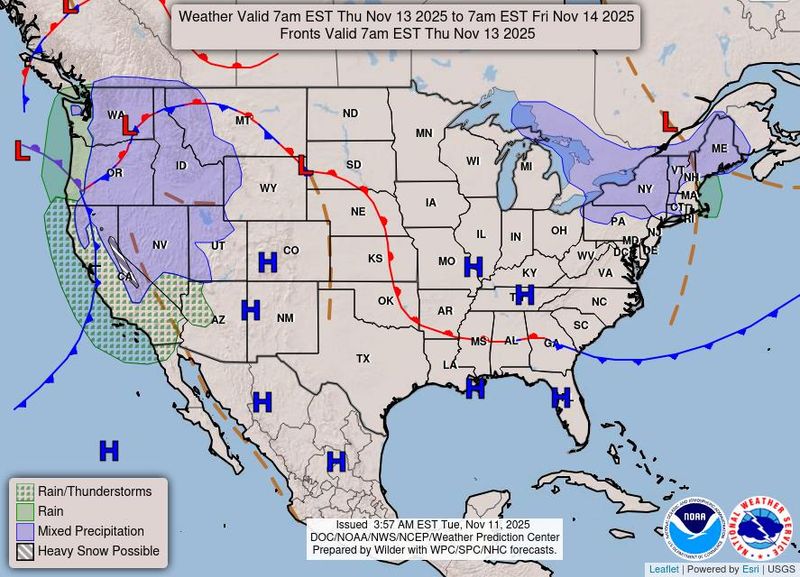
Folks flying through or to California are in for a rough ride this week, weather forecasters cautioned.
Air – and road – travelers will likely confront weather delays in the West, including California, as a potent atmospheric river storm slams the region late Wednesday, Nov. 12, and on Thursday, Nov. 13.
In California, travelers should anticipate hazardous road and air travel throughout the state, AccuWeather warned, which added that "the combination of drenching rain, heavy mountain snow and strong winds will likely cause transportation delays, affect freight and airline operations, and increase risks of power interruptions and mudslides."
Heavy snow will wreak road havoc in the mountains, while coastal and valley areas see heavy, potentially flooding rain and even mudslides. All the airports in the San Francisco and Los Angeles areas are forecast to see rain, potentially sparking delays and cancellations.
Meanwhile, travelers in the East will continue to endure heavy snow near the Great Lakes and frigid cold as far south as Florida.
100 mph wind gusts in the mountains
Some of the worst weather for road travelers will be in the Sierra Nevada.
Winds are forecast to gust above 100 mph in the mountains, the National Weather Service said, and snow will be measured in feet, not inches.
Snow will accumulate rapidly in the Sierra Nevada, with up to several feet possible above 8,000 feet and blizzard conditions at times, AccuWeather said. Donner Pass along Interstate 80 could have several inches to a foot of snow, creating treacherous travel Thursday evening and night, Nov. 13.
Rain, floods, mudslides near the coast
Coastal and valley rain could lead to floods in California, the National Weather Service said. "There's a marginal risk of excessive rainfall leading to flash flooding over portions of northern California on Wednesday night Nov. 12," the weather service said.
As for the timing of the rain, AccuWeather senior meteorologist Heather Zehr said "the bulk of the rain for San Francisco and the Bay Area in general will fall from Wednesday night Nov. 12 to Thursday morning Nov. 13."
"For the Los Angeles area, the rain should be the heaviest for the Thursday afternoon and evening rush hour on Nov. 13," she said. "Most of the rain will fall on San Diego during Thursday night and may have departed by the Friday morning rush hour."
Weather.com meteorologists warned that while the rain is beneficial, "we could see mudslides in burn scar areas."
Blustery, cold, snowy East
Arctic air has plunged southward, triggering the first significant snow of the season from the Great Lakes to the Appalachians. The early blast of winter will bring brisk winds, hazardous travel and unseasonably cold conditions into midweek, AccuWeather warned.
Lake-effect snow is expected to continue impacting downwind areas of Lakes Erie and Ontario as well as parts of the northern Appalachians, the weather service said.
"Between 4-8 inches are likely over the aforementioned areas by Thursday morning (Nov. 13)," the weather service said. "Winter weather advisories and lake effect snow warnings are in effect."
Slippery roads and reduced visibility will disrupt travel along key corridors, including Interstate 80 in Pennsylvania and routes around Buffalo and Syracuse, AccuWeather warned. "Businesses should anticipate transportation delays and potential logistical challenges as the cold pattern signals an early start to winter weather disruptions across the region," according to AccuWeather.
This article originally appeared on USA TODAY: Incoming atmospheric river storm will cause more flight problems. See forecast.
Reporting by Doyle Rice, USA TODAY / USA TODAY
USA TODAY Network via Reuters Connect

 Local News in Illinois
 Associated Press US News
 ABC News
 Reuters US Business
 2UrbanGirls Crime
 Newsday
 @MSNBC Video
 US Magazine