By Joe Lombardi From Daily Voice
A powerful storm is rolling through the Northeast, packing a punch of snow, sleet, rain, and strong winds that will make travel hazardous for millions.
The National Weather Service Weather Prediction Center said that the system tracking from the Gulf Coast will move off the Mid-Atlantic Coast on Tuesday, Dec. 2. It will strengthen as it heads up the Northeast toward the Canadian Maritimes by Wednesday morning, Dec. 3.
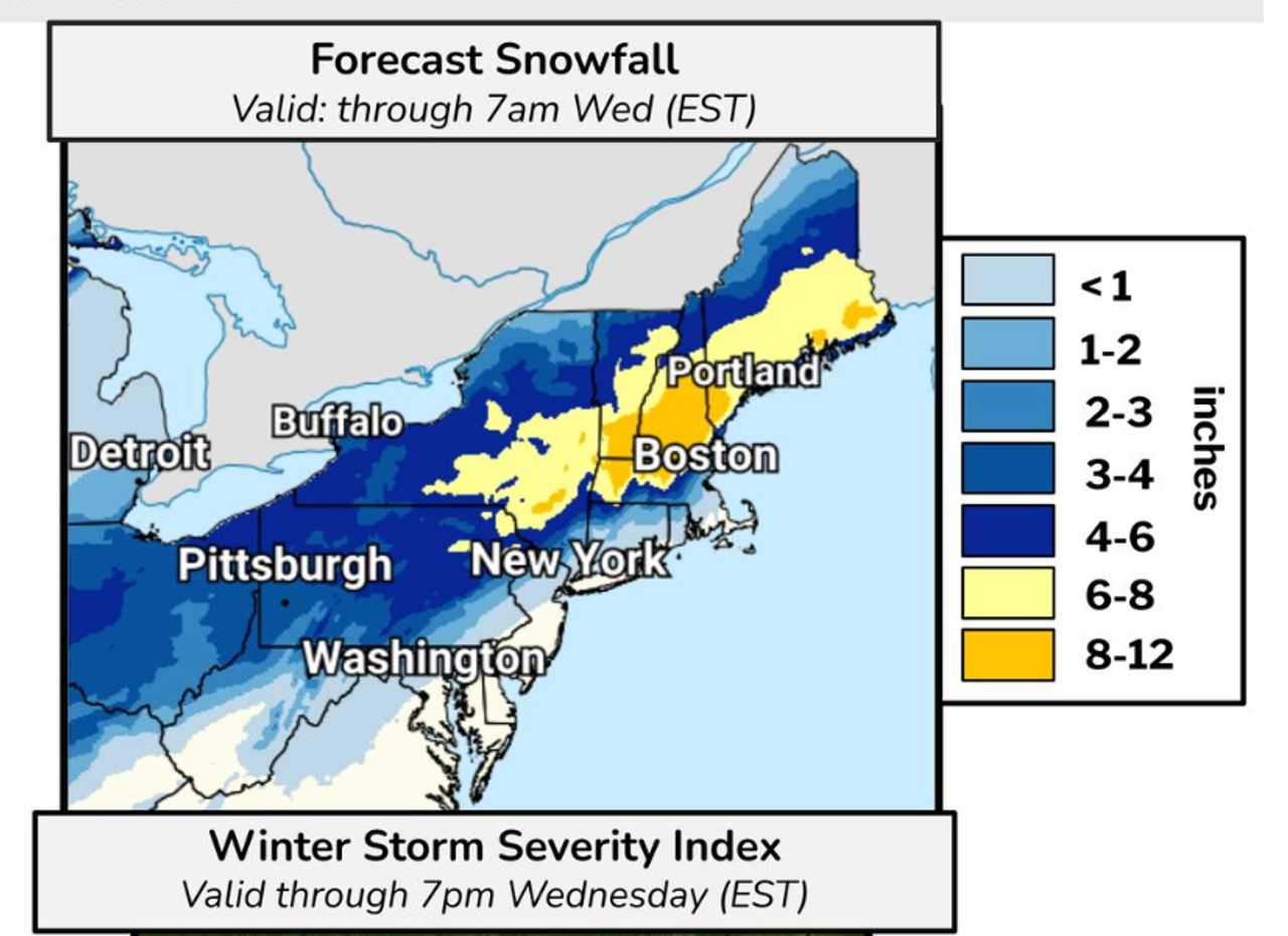
The storm is expected to bring the first widespread disruptive snow of the season for many Eastern locations, with the heaviest snow falling from the Poconos through Downeast Maine.
Snowfall rates of 1 inch per hour are likely in the interior Northeast, with a general 5 to 10 inches of snow forecast from eastern Pennsylvania through upstate New York and into New England.
Isolated spots could see more than 12 inches. Cities like Scranton, Albany, and Worcester are in line for 3 to 6 inches, while heavier totals are possible in the southern Green and White Mountains.
"Just on the other side of the rain and snow line, where the colder air is more dominant, a zone of 3-6 inches of snow is possible across eastern Pennsylvania, upstate New York and across portions of New England," said AccuWeather Meteorologist Brandon Buckingham.
A narrow zone near the rain-snow line may experience a period of sleet or freezing rain, especially across the southern and central Appalachians from western Virginia to southern Pennsylvania.
Wind gusts will be as high as 25 mph Tuesday, mainly in the afternoon.
The National Weather Service warns that freezing rain accretion of 0.1 to 0.2 inches will create slippery and dangerous conditions on roads, sidewalks, and elevated surfaces.
With temperatures above freezing along most of the coast, precipitation from the system will be all rain.
Heavy rain will also impact the I-95 corridor from the Carolinas to southern New England, with 1 to 2 inches possible in a short span. This could lead to ponding, reduced visibility, and drainage issues, especially during the Tuesday morning commute.
Behind the storm, a blast of Arctic air will sweep into the central and eastern US starting Wednesday, sending wind chills 15 to 20 degrees below actual temperatures and bringing widespread lows in the single digits and 20s.
Travelers are urged to use caution and stay updated as conditions may change rapidly.
Check back to Daily Voice for updates.

 Daily Voice


 KUOW Public Radio
 CBS News
 People Human Interest
 New York Post
 NBC Bay Area Entertainment