
 USA TODAY National
With the polar vortex catching all the buzz in recent weeks, federal forecasters say our old friend La Niña is still a major force shaping winter weather for the United States.
Federal scientists from the National Oceanic and Atmospheric Administration's Climate Prediction Center (CPC) confirmed that the La Niña weather pattern, which started in October, is expected to continue shaping U.S. weather through winter 2025-2026, according to a monthly update released Thursday, Dec. 11. December, January and February are considered winter for meteorological purposes.
La Niña and the polar vortex have already been dancing an Arctic shuffle, with the polar vortex often determining how much cold air makes it south and La Niña steering that air where she wants.
As of mid-December, a lobe of the polar vortex is getting ready to unleash unspeakably cold air across the central and eastern U.S.
After that, the vortex may be in retreat, allowing for a more typical La-Niña-like pattern to take over, at least for the end of December and into January, forecasters said.
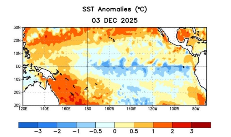
What is La Niña?
La Niña is a part of a natural climate cycle officially known as El Niño-Southern Oscillation, called ENSO by scientists. The cycle swings between warmer and cooler seawater in a region along the equator in the tropical Pacific. La Niña is marked by cooler-than-average ocean water in the region.
It is one of the main drivers of weather in the United States, especially during the late fall, winter and early spring. It's the opposite of the more well-known El Niño, which occurs when Pacific Ocean water is at least 0.9 degrees warmer than average for three months.
The intermediate stage is known as ENSO-Neutral, when neither La Niña nor El Niño are present.
Map shows how La Niña typically impacts winter weather, snow and cold
Will La Niña continue to influence weather in the US for the remainder of winter 2025-2026?
"The latest CPC seasonal outlooks shows La Niña's telltale influence on precipitation anomalies through at least February-April," said CPC climate scientist Michelle L'Heureux in a Dec. 10 e-mail to USA TODAY.
When La Niña formed in October, federal forecasters expected it to continue through February.
"The La Nina signal is consistent with drier conditions across the southern tier of states and wetter to the north," she said.
As for snow, that likely translates to a continued unusually snowy season for the Northwest, northern Rockies, the Great Lakes, and the interior Northeast.
'More normal pattern of La Niña'
With the polar vortex in retreat later this month, U.S. winter weather will be guided more by La Niña, AccuWeather Paul Pastelok told USA TODAY this week.
"This should favor a return to the more normal pattern of La Niña," he said.
When will La Niña end?
"At this point we favor a transition to ENSO-neutral during the January-March 2026 season," said L'Heureux.
Additionally, "even after equatorial Pacific sea-surface temperatures transition to ENSO-neutral, La Niña may still have some lingering influence through the early Northern Hemisphere spring 2026," the CPC report said.
Is El Niño next?
"At this point it's simply too soon to say," L'Heureux said. "There are growing chances of El Niño in mid-late 2026, but the chances remain less than 50%, which reflects the larger uncertainty we typically see as these forecasts go through the 'spring predictability barrier.'"
That barrier is when the weather models have a harder time making accurate seasonal forecasts.
If El Niño did develop, it could act to suppress hurricane activity in the Atlantic basin next year.
(This story was updated to add new information)
This article originally appeared on USA TODAY: La Niña is here for the rest of winter, federal forecasters announce
Reporting by Doyle Rice, USA TODAY / USA TODAY
USA TODAY Network via Reuters Connect

 Siskiyou Daily News
 KXLH
KXLH WMAR-2 News
 AccuWeather Severe Weather
 Eyewitness News 3
 KWWL
KWWL The News Journal
 WSIL-TV
 The Weather Channel
 KRIS 6 News Weather
 People Top Story