
 Yahoo Canada
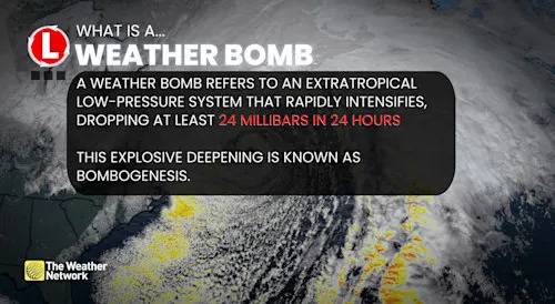
The weekend in Atlantic Canada will conclude with a powerful storm that could bring heavy snowfall and blizzard conditions to parts of the region, with impacts continuing into this week.
The intensifying system will reach the Maritime provinces and Newfoundland on Sunday night. Anywhere from 5 to 40 cm of snow is possible, depending on locale, and wind gusts could hit 100-120+ km/h. Blizzard conditions are likely in parts of Newfoundland on Monday night.
RELATED: 'WEATHER BOMBS': EXPLOSIVE STORMS THAT CREATE FEROCIOUS CONDITIONS
[Explainer: Weather bomb cyclone bombogenesis explainer (NEW FONT)] Explainer: Weather bomb cyclone bombogenesis explainer (NEW FONT)
Forecasters are confident it will be classified as a weather bomb as models are showing a drop of 30-40 mb within 24 hours.
Ad

 Mediaite
 MovieWeb
 Cover Media
 Essentiallysports Motorsports
 The Press-Enterprise
 Boing Boing
 @MSNBC Video
 She Knows