
 USA TODAY National
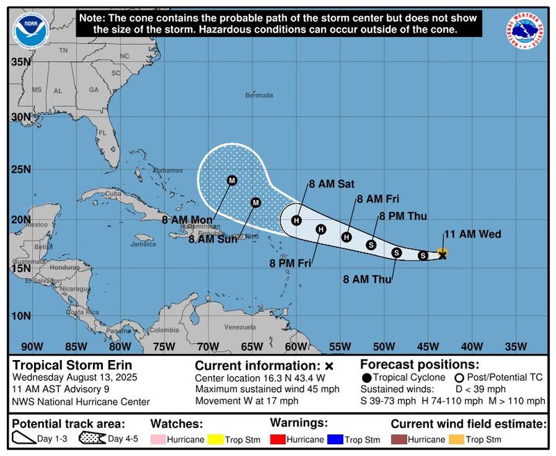
Tropical Storm Erin continues to travel west and is on pace to strengthen into the season's first major hurricane by the end of this week, the National Hurricane Center said.
According to a 11 a.m. ET advisory from the NHC on Aug. 13, Erin was located about 1,305 miles east of the northern Leeward Islands with maximum sustained winds around 45 mph with higher gusts. Erin is currently moving west near 17 mph, and this motion is expected into Thursday, according to forecasters.
A west-northwestward motion is expected to begin Thursday night and will continue into the weekend, with the center of Erin likely to move near or just north of the northern Leeward Islands over the weekend.
"Gradual strengthening is forecast to begin today, and Erin will likely become a hurricane by late Thursday or early Friday," the hurricane center said in the Aug. 13 advisory. A major hurricane is a term used for cyclones rated a Category 3 or higher with sustained wind speeds over 110 mph.
By the weekend, Erin's winds should soar to 120 mph, the hurricane center said.
Forecasters are urging interests in the northern Leeward Islands, Virgin Islands, and Puerto Rico to monitor the progress of Erin, as the storm could produce impacts on those islands this weekend. The magnitude of those impacts, however, is still not known.
Most reliable computer models that meteorologists use to forecast storms show Erin curving away from the United States, spinning off the East Coast in mid-August.
"It is too soon to discount – or pinpoint – USA landfall impacts from Erin, but based upon current model guidance – the chance RIGHT NOW is low, at less than 10%," said Weather Trader meteorologist Ryan Maue in an email to USA TODAY Aug. 11.
WPLG-TV hurricane specialist Michael Lowry added a note of caution, telling USA TODAY that "it’s worth reiterating that forecasts 5 to 10 days out are subject to large errors, so we’ll need to hang tight before confidently giving the U.S. the all-clear."
However, even if Erin does avoid landfall on the United States, "there will be a significant increase in seas, surf, and rip currents along the East Coast beaches next weekend into the following week," AccuWeather senior meteorologist Chad Merrill said.
AccuWeather Lead Hurricane Expert Alex DaSilva said to beware of rip currents at East Coast beaches: “Families heading to Atlantic beaches this weekend and next week for a late-summer vacation need to be careful. Rip currents can be deadly. More than 50 people have lost their lives to rip currents and rough surf at beaches across the country so far this year.”
Tropical Storm Erin path tracker
Illustrations include an array of forecast tools and models, and not all are created equal. The hurricane center uses only the top four or five highest-performing models to help make its forecasts.
Tropical Storm Erin spaghetti models
Illustrations include an array of forecast tools and models, and not all are created equal. The hurricane center uses only the top four or five highest-performing models to help make its forecasts.
NHC keeping tabs on 2 other systems in Atlantic, Henriette weakens in Pacific
Elsewhere in the Atlantic, the hurricane center said it is tracking a tropical wave over the northwestern Caribbean Sea that is producing disorganized showers and thunderstorms.
This system is forecast to move west-northwestward and cross the Yucatan Peninsula later today with no significant increase in organization, the hurricane center said on Aug. 13. Some development of this system is possible after it emerges across the southwestern Gulf beginning Aug. 14, however the NHC gives it a 20% chance of formation through the next seven days.
Additionally, the hurricane center said a non-tropical area of low pressure located a few hundred miles southeast of Nova Scotia, Canada, is producing showers and thunderstorms.
Limited tropical or subtropical development is still possible on Aug. 13 as the system lingers near the warm waters of the Gulf Stream; however, it is forecast to move northward over cooler waters, which will diminish its chance for tropical development.
In the Pacific, Henriette has weakened into a post-tropical cyclone with maximum sustained winds near 45 mph with higher gusts. Hurricane center forecasters said Henriette should continue to weaken and dissipate later this week.
How do hurricanes form?
Hurricanes are born in the tropics, above warm water. Clusters of thunderstorms can develop over the ocean when water temperatures exceed 80 degrees. If conditions are right, the clusters swirl into a storm known as a tropical wave or tropical depression.
A tropical depression becomes a named tropical storm once its sustained wind speeds reach 39 mph. When its winds reach 74 mph, the storm officially becomes a hurricane.
Prepare now for hurricanes
Delaying potentially lifesaving preparations could mean waiting until it’s too late. "Get your disaster supplies while the shelves are still stocked, and get that insurance checkup early, as flood insurance requires a 30-day waiting period," the National Oceanic and Atmospheric Administration recommends.
- Develop an evacuation plan. If you are at risk from hurricanes, you need an evacuation plan. Now is the time to begin planning where you would go and how you would get there.
- Assemble disaster supplies. Whether you’re evacuating or sheltering in place, you’re going to need supplies not just to get through the storm but for a possibly lengthy aftermath, NOAA said.
- Get an insurance checkup and document your possessions. Contact your insurance company or agent now and ask for an insurance checkup to make sure you have enough insurance to repair or even replace your home and belongings. Remember, home and renters insurance doesn’t cover flooding, so you’ll need a separate policy for it. Flood insurance is available through your company, agent or the National Flood Insurance Program. Act now, because flood insurance requires a 30-day waiting period.
- Create a family communication plan. NOAA says you should take the time now to write down a hurricane plan and share it with your family. Determine family meeting places and make sure to include an out-of-town location in case of evacuation.
- Strengthen your home. Now is the time to improve your home’s ability to withstand hurricanes. Trim trees; install storm shutters, accordion shutters, and impact glass; seal outside wall openings.
Gabe Hauari is a national trending news reporter at USA TODAY. You can follow him on X @GabeHauari or email him at Gdhauari@gannett.com.
This article originally appeared on USA TODAY: Tropical Storm Erin to become major hurricane soon: See tracker
Reporting by Gabe Hauari and Doyle Rice, USA TODAY / USA TODAY
USA TODAY Network via Reuters Connect

 FOX 13 Tampa Bay
 CBS Philly
 WSJM
WSJM IndyStarSports
 Glam
Glam WVTM 13 Politics
 America News
 AlterNet
 RadarOnline
 WFMJ-TV Sports
 The Cut
 Raw Story