
 USA TODAY National
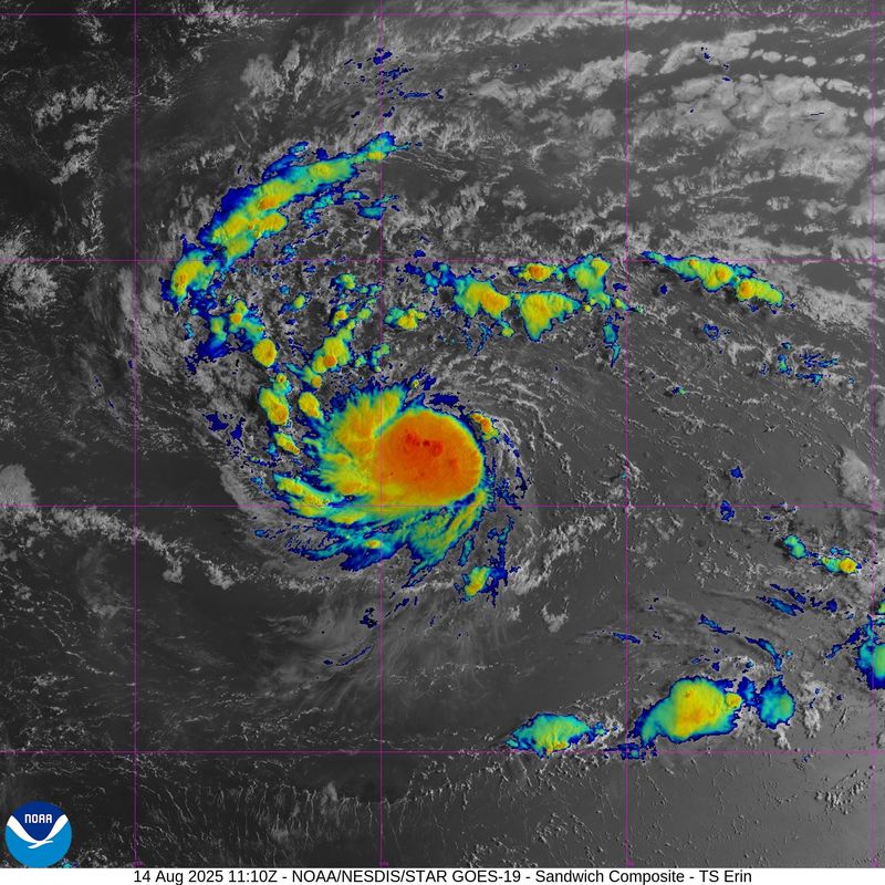
Tropical Storm Erin is continuing its path west on the way to becoming a major hurricane this weekend and the first hurricane of the 2025 Atlantic season, forecasters said.
As of 11 a.m. ET advisory on Aug. 14, Erin was located about 890 miles east of the northern Leeward Islands with maximum sustained winds around 60 mph with higher gusts after strengthening some since earlier morning, the National Hurricane Center said. Erin is currently moving west at about 17 mph, and this motion is expected through Thursday, with a west-northwestward motion beginning Thursday night and continuing into the weekend, according to forecasters.
If Erin stays on track, it is expected to strengthen into a hurricane by 2 p.m. on Aug. 15 and a major hurricane of Category 3 or higher within three days, the hurricane center said. Gradual strengthening is forecasted over the next day with more significant intensification at the end of the week and into the weekend.
"There continues to be confidence that Erin will be a large and powerful hurricane over the southwestern Atlantic Ocean this weekend," the hurricane center said.
The hurricane center said the center of Erin is likely to move near or just north of the northern Leeward Islands over the weekend. Swells generated by Erin will begin affecting portions of the northern Leeward Islands, the Virgin Islands and Puerto Rico by this weekend, with the swells likely to cause life-threatening surf and rip current conditions.
Most reliable computer models that meteorologists use to forecast storms show Erin curving away from the United States, spinning off the East Coast in mid-August.
However, even if Erin does avoid landfall on the United States, "there will be a significant increase in seas, surf, and rip currents along the East Coast beaches next weekend into the following week," AccuWeather senior meteorologist Chad Merrill said.
AccuWeather Lead Hurricane Expert Alex DaSilva said to beware of rip currents at East Coast beaches: “Families heading to Atlantic beaches this weekend and next week for a late-summer vacation need to be careful. Rip currents can be deadly. More than 50 people have lost their lives to rip currents and rough surf at beaches across the country so far this year.”
Tropical Storm Erin path tracker
Illustrations include an array of forecast tools and models, and not all are created equal. The hurricane center uses only the top four or five highest-performing models to help make its forecasts.
Tropical Storm Erin spaghetti models
Illustrations include an array of forecast tools and models, and not all are created equal. The hurricane center uses only the top four or five highest-performing models to help make its forecasts.
NHC also tracking a system in the Gulf
In addition to Erin, the hurricane center also said it is keeping an eye on a broad area of low pressure near the west coast of the Yucatan Peninsula that is producing disorganized showers and thunderstorms.
The system is forecast to emerge off the coast later this morning and move west-northwest across the southwestern Gulf during the next day or two, according to the hurricane center, where environmental conditions are marginally conducive for further development.
The system is also forecast to move inland over northeastern Mexico by late Friday, ending its chances of formation. The NHC gives the system a 20% chance of formation through the next seven days.
How do hurricanes form?
Hurricanes are born in the tropics, above warm water. Clusters of thunderstorms can develop over the ocean when water temperatures exceed 80 degrees. If conditions are right, the clusters swirl into a storm known as a tropical wave or tropical depression.
A tropical depression becomes a named tropical storm once its sustained wind speeds reach 39 mph. When its winds reach 74 mph, the storm officially becomes a hurricane.
Prepare now for hurricanes
Delaying potentially lifesaving preparations could mean waiting until it’s too late. "Get your disaster supplies while the shelves are still stocked, and get that insurance checkup early, as flood insurance requires a 30-day waiting period," the National Oceanic and Atmospheric Administration recommends.
- Develop an evacuation plan. If you are at risk from hurricanes, you need an evacuation plan. Now is the time to begin planning where you would go and how you would get there.
- Assemble disaster supplies. Whether you’re evacuating or sheltering in place, you’re going to need supplies not just to get through the storm but for a possibly lengthy aftermath, NOAA said.
- Get an insurance checkup and document your possessions. Contact your insurance company or agent now and ask for an insurance checkup to make sure you have enough insurance to repair or even replace your home and belongings. Remember, home and renters insurance doesn’t cover flooding, so you’ll need a separate policy for it. Flood insurance is available through your company, agent or the National Flood Insurance Program. Act now, because flood insurance requires a 30-day waiting period.
- Create a family communication plan. NOAA says you should take the time now to write down a hurricane plan and share it with your family. Determine family meeting places and make sure to include an out-of-town location in case of evacuation.
- Strengthen your home. Now is the time to improve your home’s ability to withstand hurricanes. Trim trees; install storm shutters, accordion shutters, and impact glass; seal outside wall openings.
Gabe Hauari is a national trending news reporter at USA TODAY. You can follow him on X @GabeHauari or email him at Gdhauari@gannett.com.
This article originally appeared on USA TODAY: When will Tropical Storm Erin strengthen into a hurricane? See path tracker
Reporting by Gabe Hauari and Jeanine Santucci, USA TODAY / USA TODAY
USA TODAY Network via Reuters Connect

 America News
 Kitsap Sun
 WTAJ-TV
 The Denver Post
 Ocala Star-Banner
 NBC News
 AlterNet
 Los Angeles Times Arts