By Joe Lombardi From Daily Voice
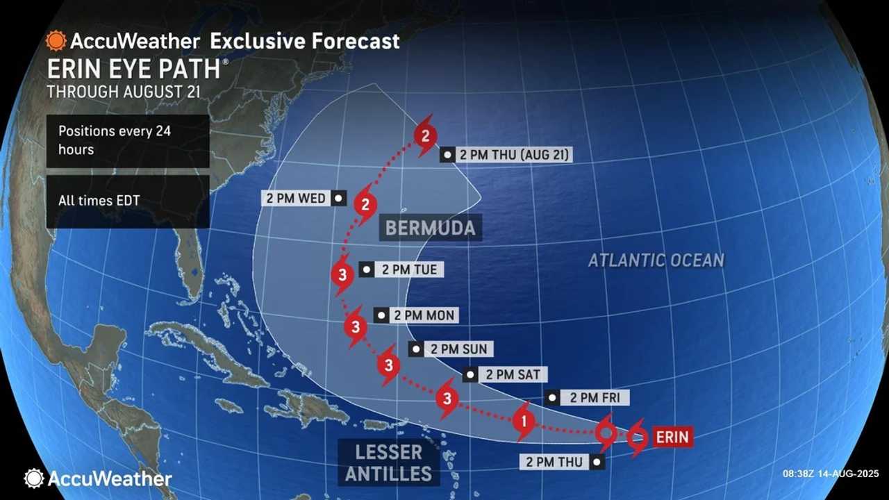
A brewing powerhouse in the Atlantic, Tropical Storm Erin is gaining strength and is forecast to become the season’s first hurricane by the weekend.
It has the potential to be a major hurricane, prompting millions along the US East Coast and Caribbean to keep a close watch.
“People along the East Coast from the Carolinas to New England and Atlantic Canada should monitor forecast updates closely through the weekend," AccuWeather Lead Hurricane Expert Alex DaSilva said.
As of the National Hurricane Center’s 5 a.m. advisory on Thursday, Aug. 14, Erin was centered about 990 miles east of the northern Leeward Islands, moving west at 17 mph with maximum sustained winds of 50 mph.
“The current forecast track keeps Erin offshore, but the East Coast is not in the clear," DaSilva said. "A westward shift in the track could bring some rain and wind impacts to eastern North Carolina, Long Island, and southeastern New England.
"An eastward shift in the track could bring Category 3 hurricane conditions to Bermuda next week. People need to be prepared as we head into the heart of hurricane season.”
Forecasters expect the storm to intensify quickly, becoming a hurricane by Friday, Aug. 15 and likely reaching Category 3 strength early next week as it tracks between Bermuda and the US coastline.
While Erin’s core is projected to stay well north of the Caribbean, dangerous conditions are still likely.
The storm’s large wind field will generate high surf, strong rip currents, and tropical-storm-force gusts up to 60 mph in the Virgin Islands and Puerto Rico this weekend. Rainfall totals of 1-2 inches are expected, with localized amounts up to 7 inches, raising the risk of flash flooding.
The risk of hazardous surf and minor coastal flooding will increase from Florida to Atlantic Canada, particularly on north- and east-facing shores, as Erin’s swells intensify through late week.
The exact impact on the US coast will depend on when Erin curves northward; residents are urged to stay alert as hurricane season nears its peak.
“Erin is moving into an area of the Atlantic primed for rapid intensification," DaSilva said. "The waters are incredibly warm. There’s little disruptive wind shear, dry air, or dust to slow this storm down."
With several tropical waves being monitored across the Atlantic, experts emphasize this is the time to review preparedness plans. Stay tuned for updates as Erin’s track and intensity continue to evolve.
“Erin has not yet started to curve north, as of Thursday morning," notes DaSilva. "The longer Erin tracks west before turning north, the odds increase of impacts potentially reaching the East Coast."
Check back to Daily Voice for updates.

 Daily Voice


 New York Post
 ICE News
 Raw Story
 Truthout