
 WWSB
WWSB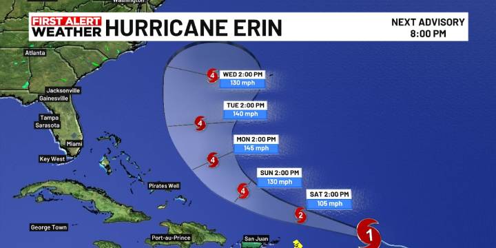
SARASOTA, Fla. (WWSB) - Hurricane Erin has become the first hurricane of the 2025 Atlantic season and is forecast to rapidly intensify into a powerful Category 4 storm this weekend, with winds near 145 mph.
Erin is tracking well offshore of the southeastern United States, turning north early next week and staying far from the Florida coastline.
Florida impacts: What does it mean for you?
Forecast models show Erin will remain well offshore, turning north early next week.
East Coast Florida: No rain or wind threat from Erin, but expect rough surf and elevated rip currents beginning early-to-mid next week.
Suncoast (West Coast): No direct impacts, just your typical afternoon sea breeze storms.
Model consensus & forecast confidence
Confidence in Erin’s forecast path is notably high. A

 The Greenville News
 The Denver Gazette
 CBS4 Miami
 America News
 CNN
CNN Associated Press US and World News Video
 Associated Press Top News
 KHOU 11 Texas
 WISC-TV Channel 3000
 Crooks and Liars