
 WDSU New Orleans
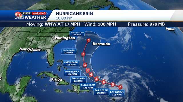
Erin is now a category 2 hurricane as it enters the western Atlantic moving quickly west-northwest at 17 mph with winds up to 100 mph.
Advertisement
The storm has strengthened to a Category 2 storm with winds up to100 mph with a minimum central pressure of 979 millibars. The hurricane has now formed a defined eye and is moving through warmer waters that will now aid in its rapid intensification. Hurricane Erin is forecast to become a major, Category 4 Hurricane this weekend with winds up to 145 mph. Erin is most likely at the beginning stages of rapid intensification.
Forecast data show Hurricane Erin will be a very large storm too. We measured the diameter of the storm to be over 650 miles according to this data.
Track guidance is now very consistent in keeping Erin over open water.

 News4JAX
 CBS4 Miami
 CNN
CNN KHOU 11 Texas
 Local News in North Carolina
 WCNC Charlotte Weather
 Associated Press Top News
 The Fayetteville Observer
 The Telegraph