
 WDSU New Orleans
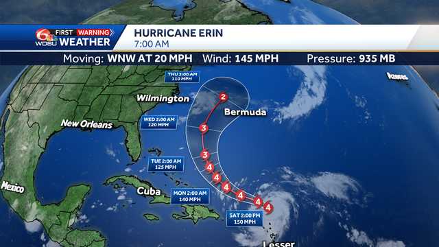
Erin is now a category 4 hurricane and moving quickly west-northwest at 20 mph with winds up to 130 mph.
Advertisement
Erin has undergone rapid intensification. It went from a tropical storm on Friday morning to a major category 4 hurricane north of the Leeward Islands on Saturday morning.
Forecast data show Hurricane Erin will be a very large storm too. We measured the diameter of the storm to be over 650 miles according to this data.
Track guidance is now very consistent in keeping Erin over open water.
Tropical Storm Watches are now up for some of the most northern Leeward Islands. There could also be concerns along the East Coast of the U.S. dealing with rip currents.
IMPACTS TO SOUTHEAST LOUISIANA:
None

 CNN
CNN KHOU 11 Texas
 Local News in North Carolina
 WCNC Charlotte Weather
 Associated Press Top News
 The Fayetteville Observer
 RealClear Politics
 Glam
Glam