
 TMJ4 News
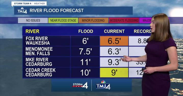
Storm Team 4 is monitoring a weekend of wet weather for the Badger State. Rounds of showers/storms are in the forecast starting tonight through Tuesday. While not every day will be a washout, there is considerable uncertainty about exactly where and when the heaviest rain will fall.
The first round may begin late tonight as showers/storms form in central Wisconsin. Some high-resolution models have suggested storms may break off this corridor and head towards SE Wisconsin first thing Saturday morning. Heavy rain is the primary concern given the recent flooding in the area. There is also a chance that storms may remain farther North and leave southern Wisconsin mainly dry.
Regardless, Saturday looks steamy. A lack of rain will allow temperatures to soar into the upper 80s and lower 90s. De

 Eyewitness News 3
 Daily Herald
 Associated Press Top News
 New Jersey News
 KWWL
KWWL KPTV Fox 12 Oregon
 AccuWeather Severe Weather
 Akron Beacon Journal
 Florida Today
 AlterNet