By Joe Lombardi From Daily Voice
As Hurricane Erin churns off the Atlantic, its growing power threatens to send dangerous waves and life-threatening rip currents crashing onto the US East Coast, even as its eye remains far out at sea.
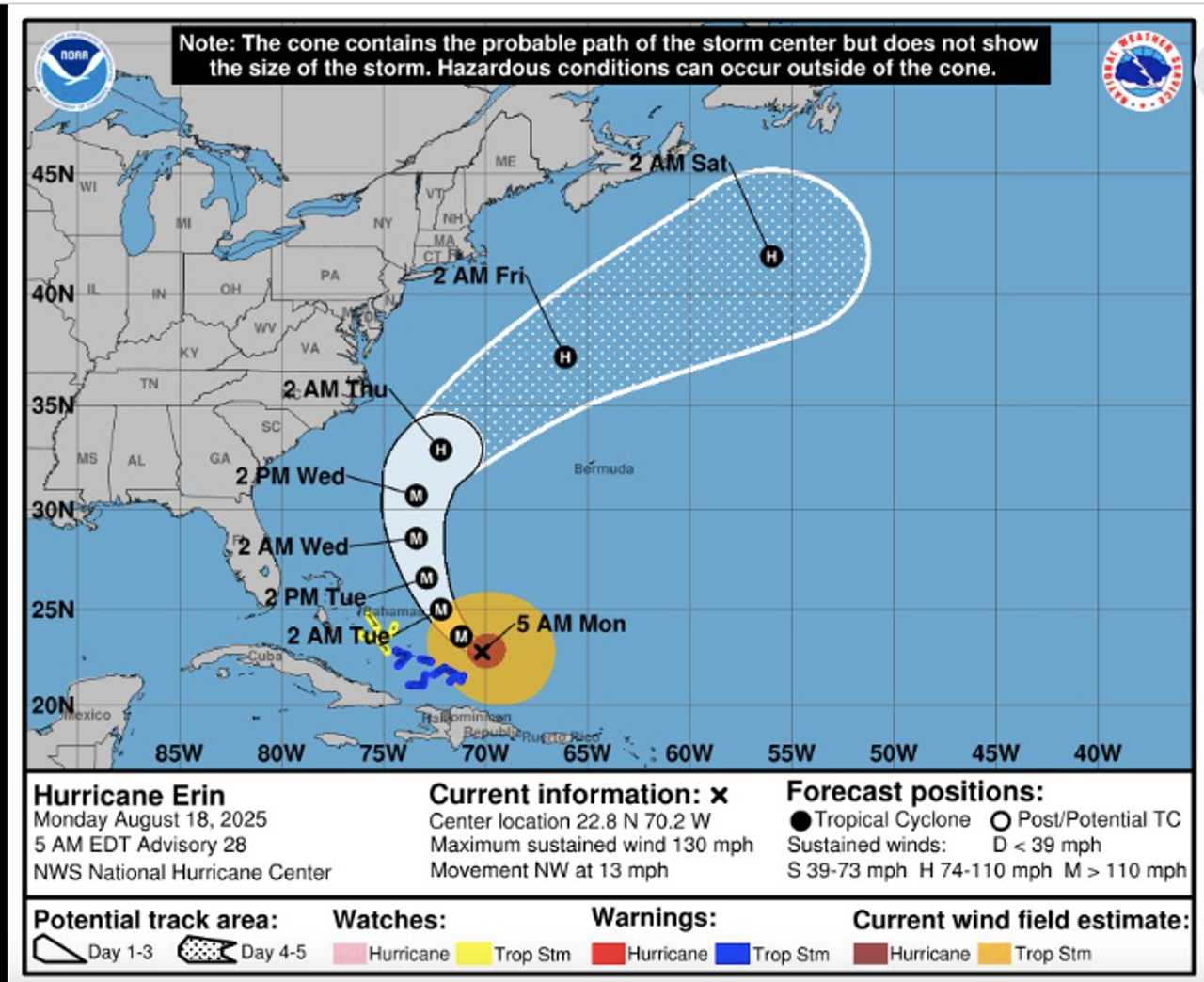
Erin, now a major Category 4 storm, is forecast to grow even larger and unleash hazardous conditions along the Atlantic coast this week, according to the National Hurricane Center and AccuWeather.
As of Monday morning, Aug. 18, Erin’s maximum sustained winds have surged to 130 mph, with the storm’s center positioned about 130 miles east-northeast of Grand Turk Island and moving northwest at 12 mph, according to the hurricane center's latest update.
While the hurricane’s eye is expected to stay offshore, AccuWeather meteorologists warn that Erin’s expanding size will have “far-reaching” impacts.
Tropical storm-force winds already extend up to 230 miles from the center, and hurricane-force winds reach outward 80 miles.
According to AccuWeather Meteorologist Brandon Buckingham, Erin has undergone a typical hurricane occurrence known as eyewall replacement.
"This means that as the old eyewall expands outward, a new eyewall forms closer to the center," Buckingham said. "Top winds often ease back during this cycle, but it is followed by another surge in wind intensity as the new eye completes organization."
Even a slight westward shift in Erin’s track could bring tropical storm conditions to parts of eastern North Carolina, while Bermuda and Atlantic Canada are also in the storm’s potential path later this week.
The National Hurricane Center cautions that life-threatening surf and rip currents will intensify along much of the US East Coast, from the Carolinas to New England, as well as in Bermuda and the Bahamas.
Waves in the surf zone could reach 5-10 feet, with some exposed beaches — like North Carolina’s Outer Banks and Cape Cod — seeing waves as high as 15 feet.
Swimmers and boaters are urged to exercise extreme caution, as rip currents will become stronger and more frequent, even on sunny days.
Tropical storm warnings remain in effect for the Turks and Caicos and the southeastern Bahamas, where heavy rainfall and flash flooding are possible through Tuesday.
Forecasters advise residents and visitors along the Atlantic coast to closely monitor Erin’s progress, as the storm’s path and intensity could shift rapidly in the coming days.
Check back to Daily Voice for updates.

 Daily Voice


 The Hill
 SIAdvance
 Honolulu Star-Advertiser Traffic
 New York Post
 stupidDOPE
 WSVN 7 News
 Reuters US Business
 Essentiallysports Golf