
 USA TODAY National
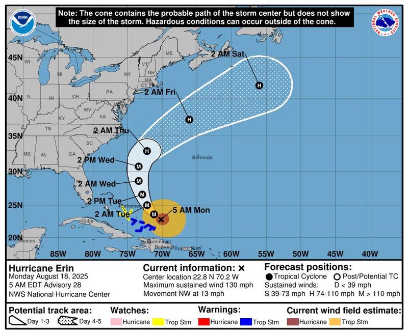
Hurricane Erin is continuing to spin in the Atlantic Ocean, bringing with it life-threatening surf and rip currents along the beaches of the Bahamas, much of the east coast of the United States, Bermuda and Atlantic Canada.
According to a 5 a.m. ET advisory from the National Hurricane Center on Aug. 18, Erin is located about 915 miles south-southeast of Cape Hatteras, North Carolina, with maximum sustained winds near 130 mph with higher gusts, making it a Category 4 hurricane on the Saffir-Simpson scale.
The hurricane center said some additional strengthening is expected throughout the day and even with weakening forecast beginning Monday night, Aug. 18, Erin will remain a "large and dangerous major hurricane" through the middle of this week.
On the forecast track, the NHC said the core of Erin is expected to pass to the east of the southeastern Bahamas Aug. 18 and move between Bermuda and the east coast of the United States by the middle of the week.
Federal forecasters warned those with interests in the Outer Banks of North Carolina and Bermuda to monitor the storm as those areas could soon face winds associated with Erin's outer rainbands.
State of emergency issued in Dare County, NC
Officials in Dare County, North Carolina, declared a state of emergency effective as of 6 p.m. ET on Sunday, Aug. 17, and issued a mandatory evacuation for Hatteras Island.
"While Hurricane Erin is expected to stay well off our coast, the system will continue to increase in size and is forecast to bring life-threatening impacts to the Dare County coastline," officials said in an Aug. 17 news release. "Coastal flooding and ocean overwash are expected to begin as early as Tuesday, Aug. 19 and continue through Thursday, Aug. 21," officials said, noting that portions of N.C. Highway 12 on Hatteras Island will likely be "impassable" for several days.
Hurricane Erin path tracker
This forecast track shows the most likely path of the center of the storm. It does not illustrate the full width of the storm or its impacts, and the center of the storm is likely to travel outside the cone up to 33% of the time.
Hurricane Erin spaghetti models
Illustrations include an array of forecast tools and models, and not all are created equal. The hurricane center uses only the top four or five highest-performing models to help make its forecasts.
National Hurricane Center keeping tabs on another tropical wave in the Atlantic
In addition to Erin, the hurricane center said it is also keeping an eye on a tropical wave located over the eastern tropical Atlantic that is producing disorganized showers and thunderstorms.
Forecasters said in an Aug. 18 advisory that environmental conditions appear conducive for gradual development of this system, and a tropical depression could form during the latter part of this week.
The system is forecast to move westward to west-northwestward and approach the vicinity of the Leeward Islands toward the end of the week, with the NHC giving it a 50% chance of formation through the next seven days.
How do hurricanes form?
Hurricanes are born in the tropics, above warm water. Clusters of thunderstorms can develop over the ocean when water temperatures exceed 80 degrees. If conditions are right, the clusters swirl into a storm known as a tropical wave or tropical depression.
A tropical depression becomes a named tropical storm once its sustained wind speeds reach 39 mph. When its winds reach 74 mph, the storm officially becomes a hurricane.
Prepare now for hurricanes
Delaying potentially lifesaving preparations could mean waiting until it’s too late. "Get your disaster supplies while the shelves are still stocked, and get that insurance checkup early, as flood insurance requires a 30-day waiting period," the National Oceanic and Atmospheric Administration recommends.
- Develop an evacuation plan. If you are at risk from hurricanes, you need an evacuation plan. Now is the time to begin planning where you would go and how you would get there.
- Assemble disaster supplies. Whether you’re evacuating or sheltering in place, you’re going to need supplies not just to get through the storm but for a possibly lengthy aftermath, NOAA said.
- Get an insurance checkup and document your possessions. Contact your insurance company or agent now and ask for an insurance checkup to make sure you have enough insurance to repair or even replace your home and belongings. Remember, home and renters insurance doesn’t cover flooding, so you’ll need a separate policy for it. Flood insurance is available through your company, agent or the National Flood Insurance Program. Act now, because flood insurance requires a 30-day waiting period.
- Create a family communication plan. NOAA says you should take the time now to write down a hurricane plan and share it with your family. Determine family meeting places and make sure to include an out-of-town location in case of evacuation.
- Strengthen your home. Now is the time to improve your home’s ability to withstand hurricanes. Trim trees; install storm shutters, accordion shutters, and impact glass; seal outside wall openings.
Gabe Hauari is a national trending news reporter at USA TODAY. You can follow him on X @GabeHauari or email him at Gdhauari@gannett.com.
This article originally appeared on USA TODAY: Hurricane Erin path tracker: See where the Category 4 storm is headed
Reporting by Gabe Hauari, USA TODAY / USA TODAY
USA TODAY Network via Reuters Connect

 WESH 2 News
 10 Tampa Bay
 The News Journal
 Local News in South Carolina
 Orlando Sentinel
 America News
 KRWG Public Media
 WCNC Charlotte Weather
 Sarasota Herald-Tribune
 Chicago Star Media
 AccuWeather Severe Weather
 Raw Story