By Joe Lombardi From Daily Voice
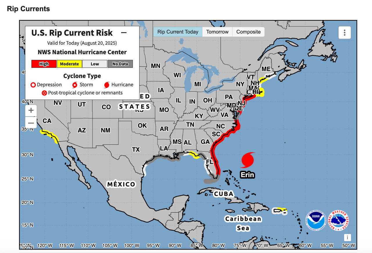
A massive, churning Hurricane Erin is turning the Atlantic into a danger zone for beachgoers from Florida to Massachusetts, prompting urgent warnings to stay out of the water as life-threatening surf and rip currents pound the East Coast on Wednesday, Aug. 20.
The National Hurricane Center has issued a high risk of rip currents for most East Coast beaches through Thursday, Aug. 21, as Erin’s powerful winds and enormous size generate pounding surf and hazardous conditions along 2,000 miles of shoreline.
“The best advice? Stay out of the water,” the agency urged, warning that even experienced swimmers and surfers could be swept away by the relentless currents.
Although Erin’s winds have eased since its peak as a Category 5 storm last weekend, the hurricane remains a formidable force, according to the hurricane center's latest update, issued Wednesday morning.
""Hurricane Erin is producing a tremendous amount of wind and wave energy that will create hazardous beach conditions from Florida to New England," AccuWeather Lead Hurricane Expert Alex DaSilva said.
Soaking rainfall is expected throughout the Northeast from late Wednesday afternoon into the evening.
Its vast wind field is acting “like a giant plunger,” according to AccuWeather, sending massive swells toward the coast and causing waves of 5 to 10 feet from the Carolinas to New England.
In some areas, especially along the North Carolina and Virginia coasts, waves could reach 10 to 20 feet, with open-ocean swells near the storm’s center approaching a staggering 50 feet.
Erin is forecast to pass about 200 miles east of Cape Hatteras, North Carolina, but its impacts will be felt far inland.
Tropical-storm-force winds of 40 to 60 mph are expected in eastern North Carolina, with gusts up to 40 mph possible as far north as southern New England.
Coastal communities face the threat of localized flooding, beach erosion, and a storm surge of up to 6 feet in the hardest-hit areas.
Officials urge everyone along the coast to heed warnings from lifeguards and local authorities, as conditions could become life-threatening through Saturday, Aug. 23.
Check back to Daily Voice for updates.

 Daily Voice


 KTVN
KTVN New York Post
 WSJM
WSJM Gothamist
 NBC News
 Washington Examiner
  CNN
CNN Secret NYC Top
 Democrat and Chronicle Sports