
 USA TODAY National
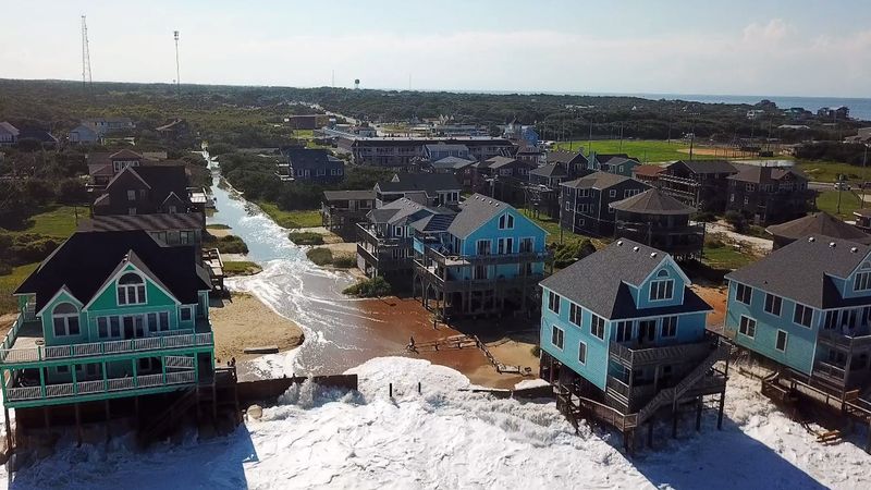
Video shows a tidal storm surge enveloping homes along North Carolina's coast as Hurricane Erin moved through the Atlantic Ocean, gaining momentum.
Aerial footage shot using a drone in the state's Outer Banks on Tuesday, Aug. 19, shows waves slamming into raised, colorful beach houses along the shore, the storm's deluge creeping its way inland.
Hurricane Erin’s surge, captured flooding the Buxton neighborhood and surrounding coastal communities, came as evacuations and swim bans were issued in the area for safety measures.
The unincorporated community on Hatteras Island near Cape Hatteras is in Dare County.
Where is Hurricane Erin headed?
On Wednesday, Aug. 20, an early morning advisory from the National Hurricane Center announced Erin was located about 455 miles south-southeast of Cape Hatteras, with winds near 100 mph.
Forecasters labeled the storm a Category 2 hurricane on the Saffir-Simpson Hurricane Wind Scale, which uses a 1 to 5 rating based on a hurricane's maximum sustained wind speed.
Weather conditions were expected to deteriorate along the state's coast, and forecasters urged caution against swimming at most East Coast beaches.
Increased wind speed is possible throughout Wednesday, Aug. 20, but the storm is expected to begin weakening by Friday, Aug. 22.
Contributing: Gabe Hauari, USA TODAY
Natalie Neysa Alund is a senior reporter for USA TODAY. Reach her at nalund@usatoday.com and follow her on X @nataliealund.
This article originally appeared on USA TODAY: Hurricane Erin waves slam into North Carolina homes: Watch
Reporting by Natalie Neysa Alund, USA TODAY / USA TODAY
USA TODAY Network via Reuters Connect

 FOX News Videos
 FOX 4 News Arlington
 FOX 10 Phoenix
 America News
 Local News in North Carolina
 CBS News Video
 AccuWeather Severe Weather
 WCNC Charlotte Weather
 People Human Interest
 Raw Story