
 USA TODAY National
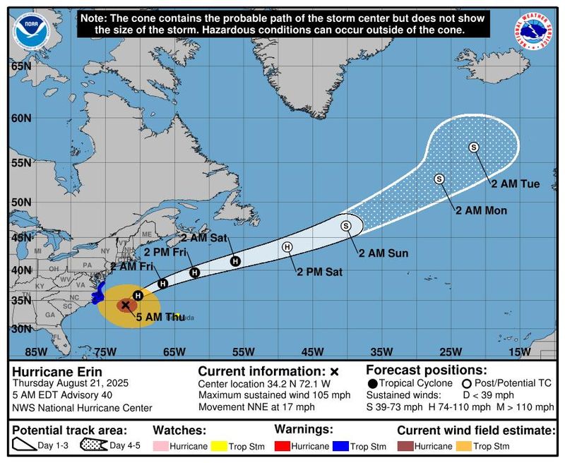
Hurricane Erin reached its closest approach to the U.S. East Coast and was just beginning to move away from North Carolina on Aug. 21, but was still unleashing powerful waves and rip currents, threatening beachfront homes and flooding roads as authorities urged people to stay out of the water.
Erin, still a large Category 2 hurricane, is expected to make a turn to the northeast and pick up speed as it pulls away from the coast later in the day. It should gradually weaken to a post-tropical cyclone by Aug. 23, forecasters said.
The National Hurricane Center has warned that roads in the low-lying barrier islands will become impassable, with powerful waves of 15 to 20 feet crashing ashore. By the evening of Aug. 20, the North Carolina Department of Transportation closed a portion of Highway 12, a crucial artery in the Outer Banks, due to flooding.
Major flooding was forecast at more than a half-dozen tidally influenced locations along the mid-Atlantic coast, including at Duck, North Carolina, around the entrance to the Chesapeake Bay, and at Lewes, Delaware, as the storm surge from Erin flowed into communities. The National Weather Service said flooding at some of these locations would pose a "significant threat" to property and life, necessitating evacuations.
On Chesapeake Bay at the Bay Bridge Tunnel, the tide is forecast to reach 6 feet high, which could cause severe flooding with extensive inundation and a significant threat to property and life, weather service records show. The severe flooding would extend inland, flooding waterfront and shoreline homes and businesses and some areas would need to be evacuated.
The 8.7-foot tide forecast at Oyster, Virginia, would send water levels up by 2 to 3 feet above dry ground with weather service data showing the severe flooding would extend inland, flooding homes and businesses and making some roads impassable under several feet of water, requiring evacuations.
Tropical storm and storm-surge warnings were in place along the North Carolina coastline. Coastal flooding was expected to peak during high tide on Aug. 21.
In New Jersey, swimming and other water activities were prohibited on beaches, with high surf and rip current warnings in effect through Aug. 22, the weather service said.
Developments:
∎ Erin was a Category 2 hurricane as of 11 a.m. ET on Aug. 21, with maximum sustained winds of 100 mph and higher gusts. It was located about 260 miles east of Cape Hatteras, North Carolina and was moving north-northeast at 18 mph.
∎ The National Hurricane Center said it is monitoring two other areas for tropical development in the Atlantic. "One has a 70% and the other 40% chance in the next 7 days," according to the hurricane center.
∎ Earlier in the week, the coastal counties of Dare and Hyde – located in North Carolina's Outer Banks region – ordered residents and tourists to evacuate the vulnerable Ocracoke and Hatteras islands, which see swelling populations during the summer months.
∎ Erin has made its closest approach to the North Carolina coast and will move further offshore, hurricane forecasters said the morning of Aug. 21. Erin's timeline for passing by the U.S. East Coast has accelerated somewhat, and it is expected to slowly weaken until it reaches post-tropical cyclone status.
Huge waves, storm surge batter Outer Banks
At 9 a.m. on Aug. 21, a buoy roughly 12 miles east of Buxton on the Outer Banks reported that the highest one-third of waves occurring there averaged 15.1 feet. Earlier, a buoy about 170 miles east of Cape Hatteras and just to the west of Erin's estimated center position reported an average wave height of 32 feet among its highest waves, according to the National Oceanographic and Atmospheric Administration.
Those big waves, combined with storm surge, are causing “significant flooding” along the Outer Banks and Highway 12, the main artery through the islands.
The Atlantic Ocean began washing over the highway on Aug. 20, pushing up over some dunes and cutting channels through piles of sand established to help protect the highway.
On the opposite side of the island from the ocean, “minor to moderate” flooding is occurring on the sound side of the islands. The National Weather Service said the flooding is expected to continue through this evening, but rough surf could continue for several days.
Sustained wind reports from the Outer Banks on the morning of Aug. 21 were between 25 mph and 40 mph, with higher gusts at various weather stations along the barrier island chain, with gusts as high as 54 mph, according to the weather service.
Widespread coastal flood advisories in New York City
Coastal flooding from Hurricane Erin is expected across much of New York City’s waterfront, possibly impacting homes, streets and businesses from Aug. 21 to Aug. 22, city officials warned.
Advisories were in place across the five boroughs, with flooding of as much as 2 1/2 feet expected on the evening of Aug. 21 in parts of southern Queens with high tide, the city Emergency Management said on X. In Queens, officials expect widespread flooding of low-lying properties, roads and basements near waterfronts. Flooding would continue with Friday’s high tides.
Manhattan, Brooklyn, the Bronx and Staten Island are projected to see 1 to 2 feet of inundation beginning the evening of Aug. 21 and into Aug. 22, city alerts warned.
Officials advised people near coastal areas to move cars to higher ground before high tide, and to protect basements, which are often converted into apartments that can be threatened by flooding.
− Eduardo Cuevas, USA TODAY
State-by-state Erin forecast details
The weather service and state officials have provided the following information:
New York: Widespread dune erosion and beach flooding are likely with successive high tides through the morning of Aug. 22, with waves of up to 15 feet or more and higher-than-normal tides. Gusts up to 40 mph are possible, with the highest winds expected along eastern Long Island.
State officials advised residents to prepare for the possibility of dangerous conditions along beaches and coastal communities. New York Mayor Eric Adams directed the closing of all beaches for swimming on Aug. 20 and Aug. 21.
New Jersey/Delaware: Tropical storm-force gusts are possible along the coast on Aug. 21, with breaking waves of 7 to 11 feet.
Maryland: Higher tides could lead to coastal flooding. Coastal flood advisories were issued, including a flood warning for Annapolis, where flooding is expected in the low-lying historic community.
Virginia: Minor or isolated coastal flooding is expected through the weekend.
Hurricane Erin tracker
This forecast track shows the most likely path of the center of the storm. It does not illustrate the full width of the storm or its impacts, and the center of the storm is likely to travel outside the cone up to 33% of the time.
Contributing: Reuters
This article originally appeared on USA TODAY: Hurricane Erin reaches closest approach to NC; dangers remain to East Coast: Updates
Reporting by Dinah Voyles Pulver, Thao Nguyen and Jeanine Santucci, USA TODAY / USA TODAY
USA TODAY Network via Reuters Connect

 WTAJ-TV
 FOX 10 Phoenix National
 NBC 10 WJAR
 America News
 Local News in North Carolina
 CBS News Video
 WCNC Charlotte Weather
 AccuWeather Severe Weather
 People Human Interest
 Foreign Policy