
 WESH 2 News
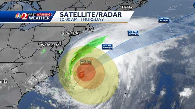
Hurricane Erin is beginning to pull away from the North Carolina coast on Thursday morning.
Erin is a Category 2 storm with maximum sustained winds of 105 mph. Latest Forecast
° F FEELS LIKE
HOURLY
DAILY RADAR TRAFFIC
As of 11 a.m., Erin was located about 260 miles southeast of Cape Hatteras, North Carolina, with an estimated minimum central pressure of 952 MB.
The hurricane is moving north-northwest at about 18 mph.
A turn toward the north-northeast is expected on Thursday, followed by a faster motion toward the northeast and east-northeast.
Erin is forecast to remain at this intensity through Friday morning before weakening to a Category 1 storm as it moves into the northern Atlantic.
On the forecast track, the center of Erin will move over the western Atlantic between

 CNN Climate
 WFTV Channel 9
 WYFF Greenvile
 America News
 CBS News Video
 WCNC Charlotte Weather
 AccuWeather Severe Weather
 People Human Interest
 RadarOnline
 Raw Story