
 FOX 13 Tampa Bay Crime
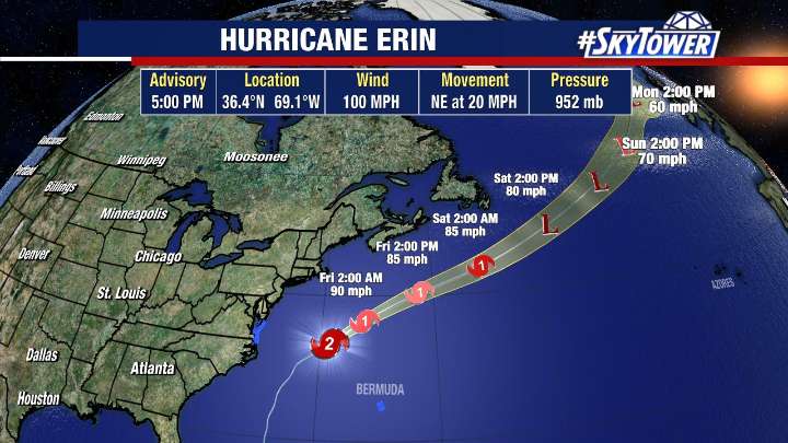
TAMPA, Fla. - As Hurricane Erin moves east of the U.S., bringing impacts along the Atlantic coast, the National Hurricane Center continues to watch three areas in the tropics for possible development.
Hurricane Erin's track
As of 5 p.m. on Thursday, Erin was located at 36.4N and 69.1W with maximum sustained winds of 100 mph.
The Category 2 hurricane is accelerating northeast at 20 mph, moving away from the United States.
Erin made its closest approach to the U.S. overnight, sending strong waves toward the Carolina coast and causing flooding in some areas.
Tropical Storm Warnings remain in effect for parts of North Carolina, Virginia and Bermuda as Erin's large wind field continues to bring widespread impacts, according to Meteorologist Nash Rhodes. Along the Outer Banks, storm sur

 CBS Mornings
 News Center MAINE
 Newsday
 WFTV Channel 9
 Jacksonville Daily Record
 CNN Politics
 FOX 5 Atlanta Crime
 Raw Story
 Slate Politics
 Reuters US Business
 Roll Call