
 Yahoo Canada
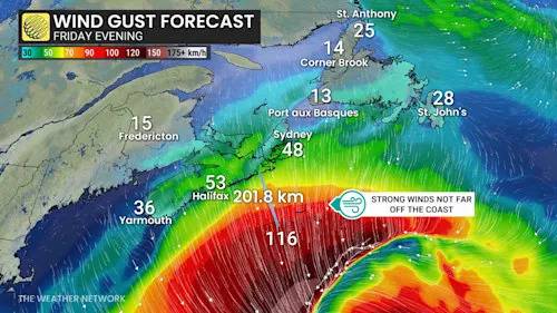
Hurricane Erin is forecast to brush past Atlantic Canada, with its impacts limited to high waves, strong winds, and overcast skies near the coast this weekend. The storm’s centre will pass south of the region on Friday before accelerating across the North Atlantic.
DON'T MISS: HURRICANE ERIN IS HUGE, HOW DOES IT COMPARE TO PREVIOUS STORMS?
By Friday night, Erin is expected to transition into a post-tropical system while maintaining hurricane-force strength through the weekend. On its current track, the storm’s most significant effects will remain over 200 km offshore, where wind gusts exceeding 100 km/h and rainfall near 200 mm are occurring.
Advertisement
Advertisement
Advertisement
Advertisement
If Erin's track had shifted just a few hundred kilometres west, its impacts on Atlanti

 Winnipeg Free Press
 Mediaite
 The Daily Bonnet