
 Associated Press Top News
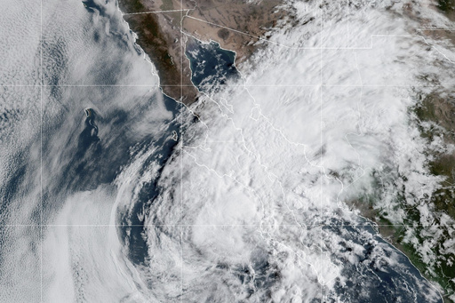
MIAMI (AP) — Hurricane Lorena weakened to a tropical storm Thursday but forecasters said a life-threatening risk of flash flooding and mudslides was still present for parts of Mexico's Baja California peninsula.
Tropical Storm Lorena had maximum sustained winds of 60 mph (95 kph), the U.S. National Hurricane Center said. The storm was centered about 140 miles (225 kilometers) west of Cabo San Lazaro, Mexico, and traveling northwest at 7 mph (11 kph).
Lorena was expected to weaken further but could still bring isolated rainfall amounts up to 15 inches (38 centimeters) to parts of the Mexican states of Baja California Sur, Baja California and Sonora. The risk of flash flooding and mudslides was expected to remain into Friday.
Forecasters urged people on the Baja California peninsula and in northwestern Mexico to monitor the storm’s progress.
In Arizona and New Mexico, the weather center said that heavy rainfall up to 5 inches (13 centimeters) was possible and issued watches for isolated flash flooding into Saturday.
Lorena's track was still uncertain, with the latest forecast suggesting the center of the storm would remain offshore just west of the Baja California peninsula. Lorena was expected to be a remnant low by Friday night.
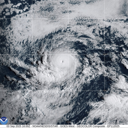
Meanwhile, Hurricane Kiko was still a Category 4 storm on the Saffir-Simpson Hurricane Wind Scale with maximum sustained winds near 130 mph (215 kph), according to the hurricane center. It was centered about 1,470 miles (2,365 kilometers) east of Hilo, Hawaii, and was traveling west at 9 mph (15 kph).
Forecasters said that Kiko was expected to fluctuate in intensity over the next two or three days.
There was also an increasing risk of impacts for Hawaii from Kiko next week. It was too soon to determine the exact location or intensity of impacts, forecasters said, so people were encouraged to monitor the hurricane's progress.
There were no watches or warnings associated with Kiko as of Thursday.

 FOX 13 Tampa Bay Crime
 First Coast Crime
 Florida Today
 The Newport Daily News
 New York Post
 KLCC
KLCC First Coast News
 NBC 7 San Diego Local
 FOX 5 Atlanta Crime
 Raw Story