
 AccuWeather Severe Weather
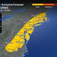
A brief surge of springlike conditions will help to fuel locally heavy to severe thunderstorms across the Midwest and East into the weekend.
Cool fronts will trigger showers and thunderstorms from the Midwest to the eastern and southern United States in the coming days. As cool air advances, brief surges of warm, humid air ahead of the fronts will produce thunderstorms with torrential downpours, strong wind gusts and hail.
Two main cool fronts will bring two rounds of gusty showers and, at times, severe thunderstorms.
By Thursday afternoon and evening, as warmer, more humid air surges north, showers and locally severe storms will extend from southeastern Ontario and southwestern Quebec to northern Georgia and Alabama.
The greatest risk of storms producing wind gusts of 50–70 mph, hail

 Shelby Star
 El Paso Times
 NewsTalk 1280
 CBS Los Angeles
 Arizona's Family
 Florida Today
 14 News
 The Daily Beast