
 USA TODAY National
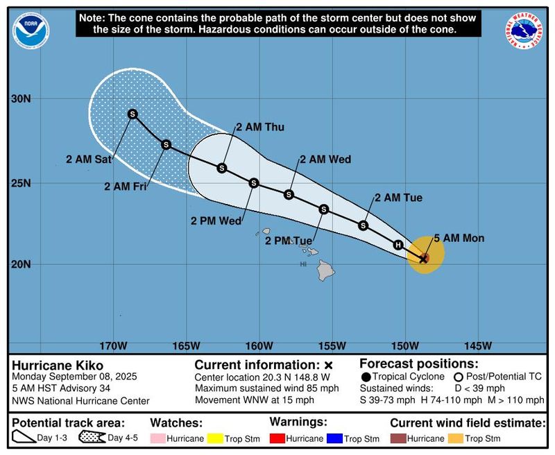
Hurricane Kiko weakened further as it churned on a path that will take it north of Hawaii, staying clear of the archipelago but still threatening the islands with possible "life-threatening surf and rip currents."
On Sept. 8, Kiko was downgraded to a Category 1 hurricane with maximum sustained winds of 85 mph, according to an 11 a.m. advisory from the National Hurricane Center in Miami. The storm was located 410 miles east of Hilo, Hawaii, and was moving west-northwest at 15 mph.
Last week, the hurricane hit Category 4 strength, but it has steadily weakened in recent days as it encountered cooler waters and wind shear. It's expected to continue losing strength and could be downgraded to a tropical storm by late day on Sept. 8, forecasters said.
Still, Kiko could bring life-threatening surf and rip currents to the islands as it passes north of Hawaii beginning Sept. 9. Dangerous conditions from the building swells will be concentrated along the eastern shores of the islands, forecasters said.
The state of Hawaii issued an emergency declaration last week, an administrative action government agencies often take before tropical storms, hurricanes and other impending weather disasters. Such declarations pave the way for emergency measures and resources that allow officials to respond quickly during emergencies.
The hurricane center says while there are no coastal watches or warnings in effect, interests in Hawaii should monitor the storm's progress.
What other storms is the National Hurricane Center tracking?
Apart from Kiko, forecasters were watching a disturbance in the eastern Pacific, just off the coast of southern Mexico.
The hurricane center said an area of low pressure could form by the end of the week, and "some slow development" is possible as it moves northwest. The disturbance has no chance of forming over the next 48 hours and a low 30% chance of forming over the next seven days, the hurricane center said.
Track active storms
This forecast cone from the National Hurricane Center shows only the probable path of the center of a storm. It does not illustrate the full range of impacts possible from a storm, such as swells, rain, and winds.
Despite lull, forecasters expect above average hurricane season
While there are no active storms in the Atlantic – an oddity as Sept. 10 marks the typical peak of hurricane season – forecasters say warm seas and a West African Monsoon will likely fuel an "above-normal season."
The National Weather Service recently updated its 2025 Atlantic hurricane season outlook and predicted there would 13 to 18 named storms, of which five to nine could become hurricanes. The season runs from June 1 through Nov. 30.
In the Atlantic, the only storm to reach hurricane strength this season has been Erin, a Category 2 storm that flooded North Carolina's Outer Banks last month and caused dangerous rip current conditions for the entire Eastern Seaboard, leading to multiple deaths.
Last week, Kiko was one of two hurricanes spinning in the Pacific basin. The other, Lorena, weakened into a tropical storm before striking western Mexico, causing power outages, floods and mudslides that swept cars away.
Contributing: Dinah Voyles Pulver
This article originally appeared on USA TODAY: Hurricane Kiko weakens to Cat 1 as it nears Hawaii, threatens dangerous surf
Reporting by Christopher Cann, USA TODAY / USA TODAY
USA TODAY Network via Reuters Connect

 Newsday
 NBC News
 Yuma Sun
 FOX 13 Tampa Bay Crime
 KMVT
KMVT News 19 WLTX
 WABI
WABI AccuWeather Severe Weather
 FOX 5 Atlanta Crime
 FOX 35 Orlando
 The Daily Mining Gazette
 Associated Press US and World News Video