
HASTINGS, Neb. (KSNB) - There are some areas of dense fog over Central into Northeast Nebraska early on this Wednesday morning. Around that, there are other areas of lighter fog or haze. Above that, there are quite a few upper level debris clouds. As the morning goes on, those upper level clouds will thin out and clear out. Meanwhile, the low clouds and fog will gradually erode away as the morning goes on. The last area to thin out will likely be in Northeast Nebraska. There is a small chance of an isolated thunderstorm over extreme Southern Nebraska and Northern Kansas. Look for highs today in the upper 70s and low to mid 80s. The coolest areas will be in the northeast. The warmest will be out west. Winds will be a little breezy out of the southeast at 5 to 15 mph with some gusts to 25 mp
Warmer temperatures are coming for the end of the week, then better chances for rain this weekend
 KSNB Local4 Central Nebraska7 hrs ago
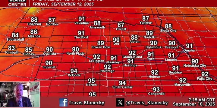
113

 KLKN-TV Lancaster County
 WOWT
WOWT AlterNet
 W Magazine fashion
 Raw Story