
 Eyewitness News 3
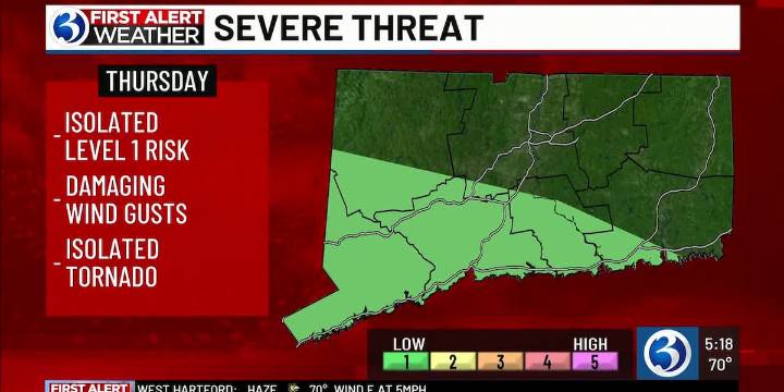
For any Alerts in effect for CT, click: here .
THIS EVENING, TONIGHT…
While initially quiet this evening, showers and storms increase in coverage as we head past sunset and into the overnight hours. The uptick in activity is compliments of a stalled boundary to our south, that begins lifting north as a warm front. Because of this, temperatures won’t drop much, only to the mid-60s where they’ll level off and remain steady.
THE REST OF THE WEEK…
Tomorrow is a *First Alert Weather Day* due to periods of rain, heavy at times, impacting both AM & PM commutes. Furthermore, we’ll be monitoring the threat for a strong to severe storms. Currently, the level 1 risk from the Storm Prediction Center encompasses the southwestern half of the state. While the greatest concern will be damaging wind

 FOX19 NOW
 CBS DFW
 WBRC
WBRC Gainesville Sun
 KICKS 105
 The radio station 99.5 The Apple
 WLOX
WLOX The Post and Courier
 WVLT
WVLT KSNB Local4 Central Nebraska