
 USA TODAY National
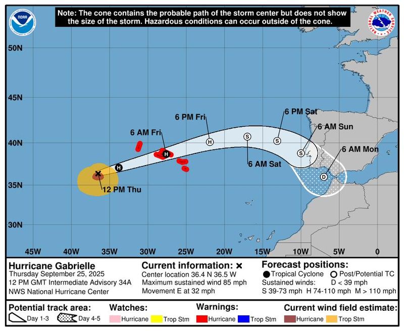
Hurricane Gabrielle is moving further away from the U.S. toward the Azores, an autonomous region of Portugal in the mid-Atlantic, according to the National Hurricane Center.
The storm is expected to reach the islands late on Thursday, Sept. 25, according to the NHC. The Meteorological Service of Portugal issued a hurricane warning for the islands.
The storm, now a Category 1 hurricane, has maximum sustained winds near 85 mph, and is forecasted to be at hurricane strength when it reaches the islands.
The storm is expected to dissipate early Saturday morning, Sept. 27, before it reaches Portugal early Sunday morning, Sept. 28.
Hurricane could cause 'life-threatening surf' on the East Coast
The storm's path has shifted away from the U.S., so there are currently no coastal watches or warnings in effect; however, swells generated by the hurricane will still impact Bermuda.
The swells are also expected to reach the east coast of the U.S. from North Carolina northward, as well as Atlantic Canada, and are expected to continue through the early part of this week, forecasters said. These swells are likely to create "life-threatening surf and rip current conditions."
Hurricane Gabrielle tracker
This forecast track shows the most likely path of the center of the storm. It does not illustrate the full width of the storm or its impacts, and the center of the storm is likely to travel outside the cone up to 33% of the time.
Hurricane Gabrielle spaghetti models
Illustrations include an array of forecast tools and models, and not all are created equal. The hurricane center uses only the top four or five highest-performing models to help make its forecasts.
Tropical Storm Humberto forms in the Atlantic
Tropical Storm Humberto has become the eighth named storm to form in the Atlantic.
As of Thursday, Sept. 25, the storm is spinning in the central Atlantic and moving toward the northwest at nearly 10 mph with maximum sustained winds of 45 mph, according to the NHC.
The storm is expected to intensify significantly over the next two to three days as it moves over warm waters.
Tropical Storm Humberto is expected to reach hurricane strength over the weekend and become a significant hurricane during the week of Sept. 28, according to the NHC.
NHC tracking one more system in the Atlantic, Hurricane Narda in the Pacific
Humberto and Gabrielle are not the only tropical activities in the Atlantic Ocean, according to the NHC.
Forecasters said they are also keeping a close eye on Invest 94L, a tropical wave located in the Eastern Caribbean Sea near the Dominican Republic as of early Thursday, Sept. 25.
The wave is producing disorganized showers and thunderstorms, and is expected to move most west-northwestward at around 10 to 15 mph, according to the NHC.
The storm will bring gusty winds and heavy rainfall to the Dominican Republic and Puerto Rico throughout the day.
The tropical wave is expected to turn northwestward once it reaches the southwestern Atlantic, and is expected to form into a tropical depression late this week once it is near the Bahamas.
In the Pacific, Hurricane Narda, a Category 1 hurricane, spins in the eastern Pacific, with maximum sustained winds of 90 mph.
The NHC has issued advisories as swells created by Narda affect areas of the southwestern and west-central Mexican coast. Later on Thursday, Sept. 25, the swells are expected to reach Baja California Sur, then southern California over the weekend.
"These swells are likely to cause life-threatening surf and rip current conditions," according to the NHC's public advisory.
Contributing: Gabe Hauari, USA TODAY
Julia is a Trending reporter for USA TODAY and covers all things Labubu and Pop Mart, scientific studies and trending news. Connect with her on LinkedIn, X, Instagram, and TikTok: @juliamariegz, or email her at jgomez@gannett.com
This article originally appeared on USA TODAY: Where is Hurricane Gabrielle headed? See the Category 1 storm's path.
Reporting by Julia Gomez, USA TODAY / USA TODAY
USA TODAY Network via Reuters Connect

 Rockford Register Star
 The Monroe News
 Asheville Citizen Times
 AccuWeather Severe Weather
 WRDW-TV News 12
 Ocala Star-Banner
 The Spokesman-Review
 WCNC Charlotte Weather
 Raw Story
 Newsday
 The Daily Bonnet