
 WYFF News 4
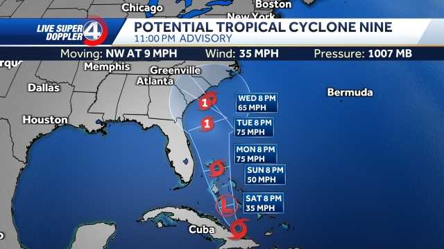
Tropical Storm Imelda formed Sunday afternoon and will bring impacts to South Carolina on Monday.
(New video will be posted above ASAP)
The system will move parallel to the coast of Florida and eventually strengthen to a Category 1 hurricane before curving out to sea.
Hurricane Stats
A Tropical Storm Watch is in effect for portions of the east coast of Florida through Monday.
Hurricane Track
Coastal Impacts:
Strong rip currents and large swells will be the highest threat to the east coast Monday through Wednesday of this week. With the curve out to sea, wind gusts could reach 30 mph with scattered showers.
Local Impacts:
Humberto will pull Imelda out to sea which decreases our impacts locally. Scattered rain is possible Monday-Tuesday. Rain totals stay at a trace to near 0.5 inche

 WRCB-TV
 FOX 5 Atlanta Crime
 Associated Press Top News
 CNN Climate
 Santa Maria Times Safety
 AccuWeather Severe Weather
 KSNB Local4 Central Nebraska
 KWWL
KWWL Arizona Republic
 Ocala Star-Banner
 Just Jared