
 USA TODAY National
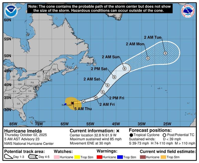
Forecasters are monitoring Imelda, now a post-tropical cyclone, as it moves away from Bermuda, according to the National Hurricane Center.
According to a late morning advisory on Thursday, Oct. 2, from the NHC, the storm is located about 315 miles east-northeast of Bermuda.
The advisory also states that the storm is moving east-northeast at 29 mph with maximum sustained winds of 75 mph. Bermuda is no longer under a tropical storm warning.
Here's what to know about Imelda.
Post-Tropical Cyclone Imelda tracker
This forecast track shows the most likely path of the center of the storm. It does not illustrate the full width of the storm or its impacts, and the center of the storm is likely to travel outside the cone up to 33% of the time.
Post-Tropical Cyclone Imelda spaghetti models
Illustrations include an array of forecast tools and models, and not all are created equal. The hurricane center uses only the top four or five highest-performing models to help make its forecasts.
Hurricane watches and warnings
While there are no tropical storm or hurricane watches in place for the U.S., significant impacts are expected as the storm creates dangerous marine conditions.
The storm is expected to create swells that can cause "dangerous surf and life-threatening rip current conditions," affecting beaches on much of the U.S. East Coast, the Bahamas and Bermuda, according to the NHC.
On Friday, Oct. 3, the swells are expected to spread to the Greater Antilles and northern Leeward Islands, where they are "likely to cause life-threatening surf and rip current conditions," according to the National Hurricane Center.
Tracking Tropical Storm Octave
Tropical Storm Octave is spinning over the tropical Eastern Pacific, according to the NHC.
The storm is moving west-northwestward at nearly 8 mph with maximum sustained winds of 65 mph, according to a 5 a.m. ET advisory on Thursday, Oct. 2.
There are no coastal watches or warnings in effect, according to the NHC.
NHC tracks 2 disturbances in the Atlantic, 1 in the Pacific
In the Atlantic, two more disturbances are moving in from the central tropical Atlantic and the southwestern Atlantic.
An area of low pressure in the Southwestern Atlantic is expected to move close to the northwestern Bahamas and southern Florida by Saturday, Oct. 4, according to the NHC. The area has a 10% chance of developing in the next 48 hours and a 10% chance of developing over the next seven days.
Any development is forecasted to be slow and will occur as the area moves towards the northwest.
A tropical wave forming in the Central Tropical Atlantic is forecast to interact with the other disturbance in the Atlantic. It could also slowly develop as the combination moves westward to northwestward at 15 to 20 mph, according to the NHC.
The storm has a new 0% chance of developing in the next 48 hours and a 20% chance of developing in the next seven days.
In the Pacific, a trough of low pressure a few hundred miles off the coast of southern and southwestern Mexico has a high chance of forming in the next seven days.
The trough is producing a large area of disorganized showers and thunderstorms and could gradually develop, according to the NHC. The area will likely form a tropical depression by Friday night, Oct. 3, or over the weekend.
The area has a 50% chance of forming over the next 48 hours, and a 90% chance over the next seven days.
How do hurricanes form?
Hurricanes are born in the tropics, above warm water. Clusters of thunderstorms can develop over the ocean when water temperatures exceed 80 degrees. If conditions are right, the clusters swirl into a storm known as a tropical wave or tropical depression.
A tropical depression becomes a named tropical storm once its sustained wind speeds reach 39 mph. When its winds reach 74 mph, the storm officially becomes a hurricane.
Prepare now for hurricanes
Delaying potentially lifesaving preparations could mean waiting until it’s too late. "Get your disaster supplies while the shelves are still stocked, and get that insurance checkup early, as flood insurance requires a 30-day waiting period," the National Oceanic and Atmospheric Administration recommends.
- Develop an evacuation plan. If you are at risk from hurricanes, you need an evacuation plan. Now is the time to begin planning where you would go and how you would get there.
- Assemble disaster supplies. Whether you’re evacuating or sheltering in place, you’re going to need supplies not just to get through the storm but for a possibly lengthy aftermath, NOAA said.
- Get an insurance checkup and document your possessions. Contact your insurance company or agent now and ask for an insurance checkup to make sure you have enough insurance to repair or even replace your home and belongings. Remember, home and renters insurance don’t cover flooding, so you’ll need a separate policy for those. Flood insurance is available through your company, agent or the National Flood Insurance Program.
- Create a family communication plan. NOAA says you should take the time now to write down a hurricane plan and share it with your family. Determine family meeting places and make sure to include an out-of-town location in case of evacuation.
- Strengthen your home. Now is the time to improve your home’s ability to withstand hurricanes. Trim trees and install storm shutters, accordion shutters, and impact glass, and seal outside wall openings.
Contributing: Gabe Hauari, USA TODAY
Julia is a Trending reporter for USA TODAY and covers all things Labubu and Pop Mart, scientific studies and trending news. Connect with her on LinkedIn, X, Instagram, and TikTok: @juliamariegz, or email her at jgomez@gannett.com
This article originally appeared on USA TODAY: Imelda now a post-tropical cyclone moving away from Bermuda. Track storm's path.
Reporting by Julia Gomez, USA TODAY / USA TODAY
USA TODAY Network via Reuters Connect

 Chicago Tribune
 Associated Press Top News
 Montomery Advertiser
 NBC News
 The Grand Rapids Press
 WBKO
WBKO WCNC Charlotte Weather
 TIME
TIME AccuWeather Severe Weather
 FOX 10 Phoenix Latest
 Just Jared