
 USA TODAY National
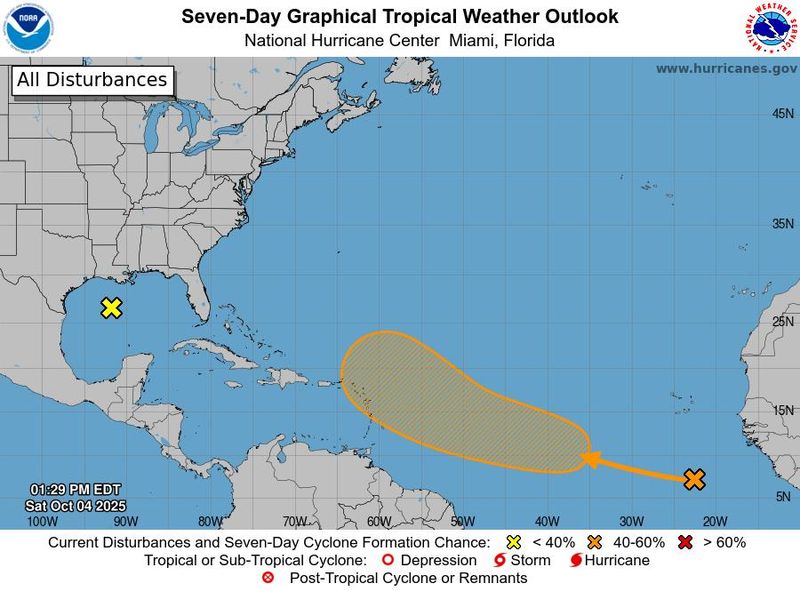
After Hurricanes Humberto and Imelda dissipated in the Atlantic, forecasters are watching the tropics for any sign of a storm stirring up that might impact the United States, but things are relatively quiet at the moment.
With just two months to go in the 2025 Atlantic hurricane season, a disturbance with a moderate chance of cyclone formation is still far out at sea while an area of low pressure in the Gulf of America, formerly known as Gulf of Mexico, is unlikely to form before it makes its way toward the Texas coast, the National Hurricane Center said on Oct. 4.
Another area of possible development near the Florida coast dropped off forecasters' watchlist on the afternoon of Oct. 4, but AccuWeather Lead Hurricane Expert Alex DaSilva said downpours are still expected over the weekend in the Southeast.
Should another weather system develop into a tropical storm, it would be named Jerry, which is next on the list of the 2025 Atlantic hurricane season names.
Here's what forecasters are watching next:
What's brewing in the Atlantic
A weak area of low pressure has formed over the north-central Gulf and is producing disorganized showers and thunderstorms off the coasts of Louisiana, Mississippi, and Alabama. This system is expected to move slowly northwestward during the next day or two, reaching the coast of Texas by Monday. Development of this system is not expected due to strong upper-level winds.
A tropical wave between the west coast of Africa and Cabo Verde Islands is producing a broad area of disorganized showers and thunderstorms. Gradual development of the wave is possible over the next few days, and it could become a tropical depression by the middle to latter part of next week while moving across the central tropical Atlantic and approaching portions of the Leeward Islands.
If that tropical wave persists, it could slowly start organizing east of the Caribbean Islands and approach the islands later as a potential named storm, AccuWeather forecasters said.
Home stretch of hurricane season
This is the first year in a decade that the U.S. has not experienced a direct hit to land by a hurricane by the end of September, AccuWeather reported.
"So far, the season is running a bit below normal for named storms and hurricanes but above-normal for major hurricanes," Colorado State University hurricane researcher Phil Klotzbach told USA TODAY.
Still, experts say it's wise to remain on guard for future activity in the Atlantic. Just last year, seven storms formed in the last two months of the season, including four hurricanes.
The Atlantic hurricane season officially began on June 1 and will last through the end of November. Active hurricane weather typically peaks between mid-August and mid-October.
Track storms in the Atlantic
Contributing: Dinah Voyles Pulver, Doyle Rice, Jennifer Borresen and Ramon Padilla
This article originally appeared on USA TODAY: Hurricane forecasters watch 2 disturbances. Track where they are headed.
Reporting by Jeanine Santucci and Jennifer Sangalang, USA TODAY NETWORK / USA TODAY
USA TODAY Network via Reuters Connect

 Local News in Florida
 Santa Maria Times Safety
 KSNB Local4 Central Nebraska
 The Washington Post
 WRBL News 3
 KNOE
KNOE Raw Story
 AlterNet
 Associated Press US News
 NECN Providence