
 KBTX News 3
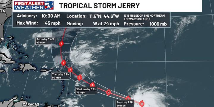
BRYAN, Texas (KBTX) - With just under two months left in the Atlantic hurricane season, we have scratched off our tenth named storm. Jerry formed in the central tropical Atlantic on Tuesday, just over 1000 miles east of the Windward Islands.
This area of showers and thunderstorms has gradually become more organized over the last few days, showing convective bands increasing around the center of circulation with the strongest winds on the storm’s east side.
The path should take Jerry quickly to the west-northwest, putting it near the northern Leeward Islands Thursday or Friday. Around this time, the forecast intensity shows at category one strength with maximum winds around 90mph. After passing the Leeward Islands, Jerry looks to take a turn to the north, paralleling the U.S. East Coast.

 The News Journal
 NBC 6 South Florida
 Wilmington Star-News
 Click2Houston
 CBS News
 KWTX News 10
 Community Impact Newspaper
 Fox 26 Liberty County
 NBC News
 FOX 4 News Arlington
 The Hollywood Reporter