
 Action News Now
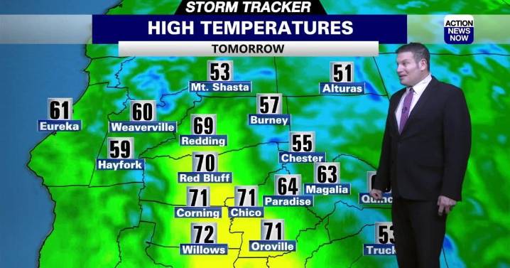
WHAT WE’RE TRACKING:
Rain chances by Friday and this weekend with more rain and mountain snow next week.
PLANNING YOUR NEXT 24 HOURS:
Mostly sunny and mild (NW 5 MPH) with a 20 percent chance of showers before 11 am
EXTENDED FORECAST:
The storms move back in from the northeast later on Sunday or Monday. Thunderstorm chances (10-20 percent) increase as the storms move on shore Monday night . Locations under 5,500 feet could see up to an inch of rain while locations above 5,500 feet could see 6" of mountain snow through Wednesday. Winds could be breezy with a warmup from Thursday on.
ACTION NEWS NOW STORM TRACKER FORECAST:
TONIGHT:
Mostly cloudy, cool and breezy
Low: 53
Wind: S 5-10/G20 MPH
TOMORROW:
Mostly sunny and mild with a 20 percent chance of showers before 11 am
High:

 WTNH News 8
 America News
 KPTV Fox 12 Oregon
 Santa Maria Times Local
 Newsday
 ABC 6 WPVI-TV
 ABC11 WTVD
 Arizona's Family
 13 On Your Side
 @MSNBC Video