
 Yahoo Canada
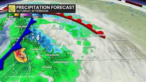
The remnants of Typhoon Nakri will be just the launch of a much wetter pattern for the B.C. coast during the final two weeks of October as a powerful Pacific jet will bring a parade of low-pressure systems.
Heavy snow is expected in alpine regions, with snow levels dropping below 1500 metres Saturday night into Sunday. This will affect travel through higher mountain passes and bring significant snowfall to areas like Whistler.
DON'T MISS: WHAT’S THE DIFFERENCE BETWEEN HURRICANES, TYPHOONS, AND CYCLONES?
Needless to say, B.C. folks along the coast should brace for potential impacts including ferry and road travel, especially in the mountain passes, and power outages. Ensure devices are charged and plan ahead before venturing out.
HEAVY RAIN AND HIGH-ELEVATION SNOW COULD IMPACT TRAVEL PL

 9&10 News
 Bozeman Daily Chronicle Sports
 Atlanta Black Star Entertainment
 Live 5 News Crime
 Axios
Axios America News
 NFL New York Giants
 WYFF Sports
 CNN
CNN Breitbart News