
 WAFB
WAFB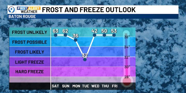
BATON ROUGE, La. (WAFB) - Warm and humid weather will continue in advance of the strong cold front through Saturday, then a big cool-down starts Sunday into next week.
DENSE FOG ADVISORY
This advisory is for some, but not all. In fact, most of the viewing area will not have cause for concern, only the eastern parishes until 8AM.
FRIDAY’S FORECAST
Today will start cloudy and dreary with a 20% chance of a few light showers this morning, then trending drier with more sun as the day wears on. Highs will again be unseasonably warm in the lower to mid 80s.
ARCTIC FRONT
This next cold front will be a strong one with the arrival expected in the pre-dawn hours Sunday morning. This front will not be much of a rain-maker, however, it will provide the area with a significant cool-down, with temp

 WJBF-TV
 NOLA
NOLA New York Post
 WWL-TV
 Page Six
 Raw Story
 AlterNet
 RadarOnline