
 WVLT
WVLT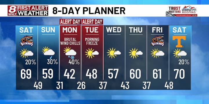
KNOXVILLE, Tenn. (WVLT) - FIRST ALERT WEATHER DAY IN PLACE for storms through midnight. A few could be severe with high wind or small hail. Tornado risk is almost zero now. Winds will be southwest at 10-20 mph with higher gusts. Lows will be in the mid 50s.
SATURDAY: Patchy dense fog in the morning, then sunny by afternoon. Highs will be in the upper 60s to low 70s. Winds will be variable at 5-10 mph.
SUNDAY: A passing shower with temperatures falling through the 50s in the afternoon as a big cold front moves through. Lows will fall to around 30 Sunday night but it will feel like the teens and 20s.
FIRST ALERT! QUICK ARCTIC BLAST MONDAY AND TUESDAY! Clouds will linger on Monday with windy and cold conditions. Highs will likely stay in the 30s to low 40s. A few showers or snow show

 Action News 5 Crime
 Dickson County Source
 AlterNet
 Raw Story
 News 5 Cleveland
 Real Simple Home